This is written from a Geographer‘s perspective. Nina Newington and the team from Extinction Rebellion would likely have a different, but complementary perspective.
Step 1 Where are the spray parcels? There were three parcels for spraying in Annapolis County. What are their PIDs? (Parcel Identification)
Given the PIDs, they can be located on a map. David Colville at COGS produced a map showing the three parcels on a topographic map base.
Step 2 How do you get to the parcels if you plan to occupy the site?
This requires field work. Driving rough logging roads looking for access points to the spray parcels. Since the decision has been made to occupy, you need good directions and maps to assist anyone interested in the occupation. David added routes to the parcel map.
Step 3 Which residents of Annapolis County will be directly impacted by the spray? i.e. down slope / down wind. The most adjacent citizens live along West Inglisville Road and Highway 201.
We produced an 8 x 11″ handout with a map of South Mountain showing the parcels. On the back, the warden’s letter to the province requesting NO Spraying in Annapolis County. We distributed the handout to citizens in the immediate area. This led to the identification of Mud Lake as part of the Village of Lawrencetown water supply catchment.
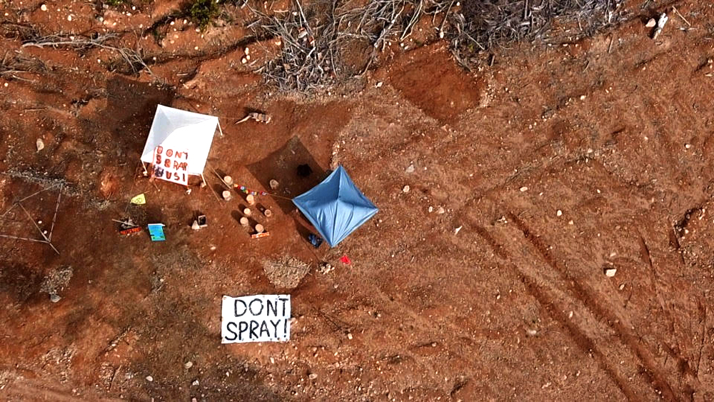
Step 4 Once the protest camp was in place, contacted Neil Green about drone photography of the site. This clearly shows the camp on the spray parcel. Release information to the media.

These are only some of the actions. Others include making signs visible from the air, placards, posters. We received excellent support from Integrity Printers, Lucky Rabbit, ARCH and PO bakery.
What are the lessons?
- Engage other like minded citizens and protest organizations
- Create products that can be understood by the different groups (i.e. maps)
- Support community organizations representing citizens e.g. Municipality of Annapolis, Village of Lawrencetown to lobby provincial government.
What next?
We now have had a second small victory – first Burlington and now Eel Weir Lake and Paradise Lake (Roxbury). We know there are 42 sites across the province approved for spraying by Nova Scotia Environment in Amherst. We have stopped 3 sites in Annapolis County and one in Kings County. Where are the other 38 sites?
What do citizens need from this government?
- A searchable map of all ‘current’ crown land.
- A map of the crown land that has been made available to the forest industry for harvest.
- A map of the land that has already been harvested by clear-cutting or ecological forestry.
- A map of the current clear-cuts. That shows which have already been sprayed. That shows which are designated for spraying. (38 sites). The spray window is September 1 – November 1.
Conclusion
Access to geographic information is critical. We need maps, drone photography, satellite imagery. These resources can help generate input from citizens as part of the decision process. We cannot achieve sustainable Forestry without these inputs. Citizens need to know when crown land has been redefined, and for what purpose.
There is a wonderful role for students at the community college (e.g. COGS) to help make this type of Geographic information available to community groups.
For a different forestry perspective, check out the CBC interview with Ken Gray, the province/WestFor is competing directly with the small loggers in SW Nova Scotia.
The bottom line … we need to start respecting the landscape, it’s inhabitants and fellow citizens. No clear-cutting and no spraying. There is a better way.
Acknowledgements
I want to acknowledge the efforts of Heather Stewart. She was instrumental in the design of posters, placards and sandwich boards. She also conducted much of the door to door contact with residents. I want acknowledge Nina Newington in her communication and coordination role. Politically, Timothy Habinski and Council, Brian Reid and the water supply committee for Lawrencetown were the interface with the provincial government. Thank you. Finally, Larry Powell for his excellent video and Neil Green for dramatic drone imagery. Edward Wedler for adding the graphics. He understands Remote Sensing too.
Postscript
Camping out in a gravel pit in a clear-cut, listening to coyotes, makes you appreciate the plight of the homeless in our cities. Reminds me of George Orwell’s book ‘Down and Out in Paris and London’.

The 43 sites approved for spraying were all on private land, or at least it is private land now. Was the parcel at Eel Weir Lake Crown land at one time? If so, how did it end up in Freeman and Son Ltd’s hands? More questions for geographers.
LikeLike
The Bowater Mersey Land became the WestFor land. I don’t know who are all the participants of WestFor. Freeman would be one
LikeLike