On Friday, I went to COGS to drop off a couple of library books. The building was deserted, and COVID protocols were in place. I did manage to spend time in the Board Room to look at the maps from the W.K.Morrison Special Collection. Walter joined the NSLSI as a Cartography instructor in 1966. He retired in 1985.
I had the opportunity to look closely at the eighteenth century nautical charts of DesBarres’ Atlantic Neptune, as well as the Herbert Moll map 1736-45 that shows the location of Annapolis Royal.
Perhaps for the first time, I fully appreciated the geographic content, the workmanship and creativity in design. Cartography is a wonderful combination of both scientific and artistic endeavour.
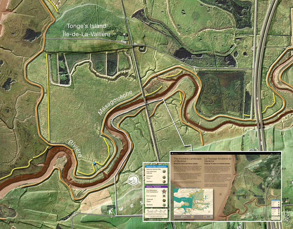
On the ramp leading to the Library, outside the AV Room, there is a stunning modern day exhibit of the maps by Marcel Morin, Lost Art Cartography. Maps include Wines of Nova Scotia, Landscape of Grand Pre, the Ancestral Landscape of Sikniktuk and the eighteenth century trade at Beaubassin.
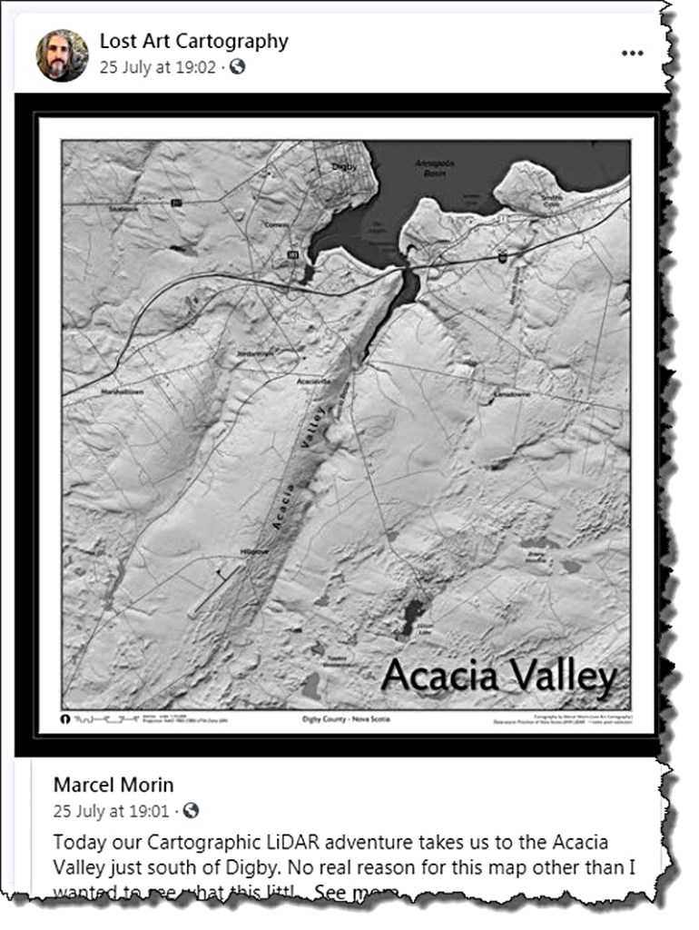
In these maps, Morin adds three dimensional representation of topography derived from LIDAR. Again, a modern example of scientific and artistic integration. Morin is a graduate of the COGS Cartography program, living in the Annapolis Valley.
ACRONYMS
In the late afternoon, I joined John Wightman for a beer. We talked about the story behind the different acronyms.
COGS: College of Geographic Sciences
This was invented in 1986 to replace NSLSI. With the formation of the NSCC, it became the Centre of Geographic Sciences. John liked the concept of cogs in a wheel. The different disciplines working together to drive forward an engine or machine. Again, the combination of artistic design, science and the enabling technology.
CANMAP
Another JFW invention. It stands for Canadian Numerical Mapping Applications. This suggests the use of computer technology, a focus on applied science, and a uniquely Canadian perspective. CANMAP has traditionally supported student graduation awards at COGS.
AGRG: Applied Geomatics Research Group
AGRG is located at the Middleton site of the Annapolis Valley NSCC campus. Again the acronym suggests a focus on applied science, using Geomatics technology, undertaken by a group of researchers.
These acronyms reflect the values and interests of a community of individuals, based in rural Nova Scotia, Lawrencetown. There are , of course, many side stories. For example, the establishment of a similar program, modelled on the COGS curriculum in Indonesia. Or the relationship between COGS and the Environmental Systems Research Institute (ESRI) in California.
Postscript.
Last night, Heather and I enjoyed listening to the nyckelharpa at the Dawn Oman Art Gallery in Bridgetown. Presented by the Harpaflojt Trio.
Acknowledgements
John Wightman for his memories of NSLSI and COGS. David Raymond for encouraging a closer look at the WK Morrison Special Collection. Edward and Heather for their ongoing support.
VISIT COGS ! Preferably, once the students and faculty have returned in September. Check out the Story of COGS web site.

Bob
Always interesting!
Any thoughts on the relationship between mapping and aerial photography, especially pre-digital. My understanding is that the gov’t of Canada began stereoscopic aerial photography of the whole country following WW 1 using Vickers (?) bombers. If so, there is a 100 year history of co-relative mapping.
Brian
Brian Arnott Principal Novita Interpares | Leaf + Branch
novitainterpares.ca >
LikeLike
Brilliant resource, Brian! I’ve actually seen high-resolution, high altitude airphotos over Nova Scotia from such aircraft (1:80,000 scale). Further, I’d like to see AGRG/COGS set up a program to capture, study and research repeat (seasonal, annual, day/night) drone imagery/sensors over specific longitudinal/site-specific targets in Nova Scotia — something following the template designed by a former Director of the Ontario Centre for Remote Sensing.
LikeLike