In preparation for a presentation at the specialist workshop on AF Church Historical Maps in Truro on August 14, I checked with David Raymond on his current definition of ‘Historical GIS’. In return, he sent me a link to a product developed by Esri’s StoryMaps team ‘Mapping Irish Surnames ‘. Of course, I could not resist keying in my surname, Maher.
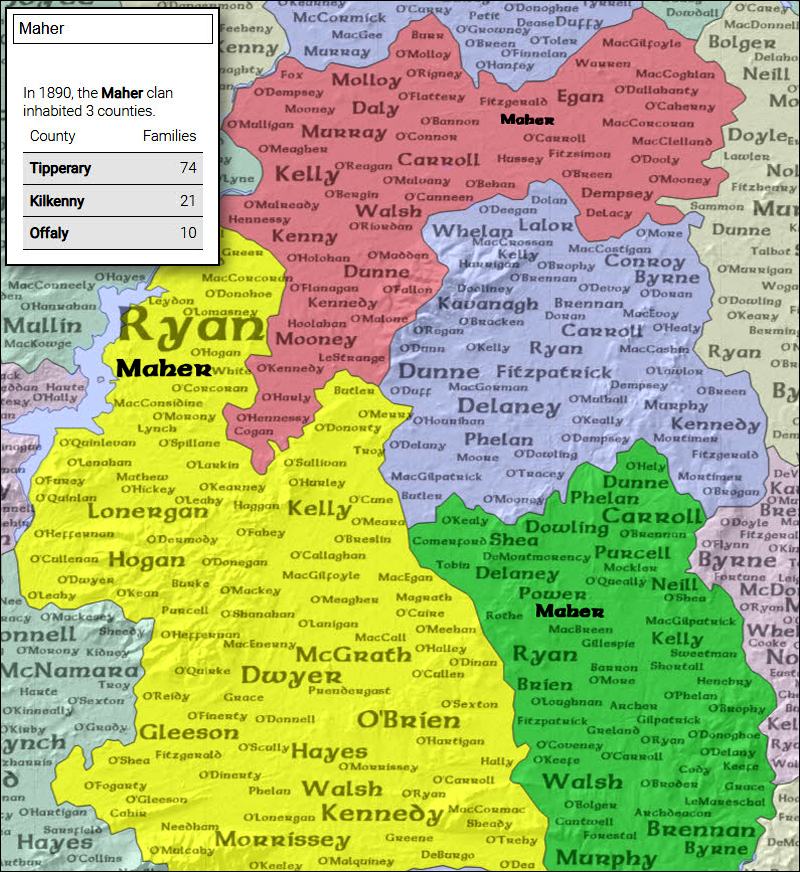
In 1890, the Maher clan inhabited three counties.
County Families
Tipperary 74
Kilkenny 21
Offaly 10
How does this relate to the AF Church historical maps?
The Church maps give us cartographic coverage for Nova Scotia. The maps show us the existing road infrastructure, schools, churches, stores, mills, post office etc.. ln addition, there is the location of houses with the owner’s name.
Put in GIS terms, we have a point coverage (house location) and attributes (owner name). We could create a point layer (owner name) and also a polygon layer (county). This would allow us point in polygon analysis, thereby replicating the functionality of the Irish Surname project.
There are a number of GIS/Cartographic challenges. We must ensure that the map layers in the GIS all adhere to the same reference system and projection. This would ensure that the buildings are in their correct position on the earth’s surface, and that they lie within the correct county boundary.
The challenge for the attendees of the workshop will be to consider other features/content of the AF Church maps which can be studied within a GIS context (e,g. other infrastructure – mills, stores, hotels churches etc., plus other historic sources which can be geo-referenced to a modern representation of the Church maps.
In a follow-up blog, I will consider other data sets which may help us understand the changes in landscape, as the result of changing settlement patterns and land use. This will reflect changes in cartography, GIS technology and other new technologies such as drones, LiDAR, ground-penetrating radar.
Acknowledgements
Thanks to David Raymond for sharing his knowledge and links. Edward Wedler, John Wightman and others, reflected on the availability of historical satellite and aerial photography.
References
AF Church Historical Maps Specialist workshop, August 24, 2021, Truro, NS. Sponsored by Heritage Trust of Nova Scotia, Royal Nova Scotia Historical Society, KITH Observatory Inc.
Esri StoryMaps Team, March 2020, Mapping Irish Surnames.
POSTSCRIPT
I challenge COGS to explore mapping development/research opportunities with ancestry.com
from Edward
Link: https://video.mainepublic.org/show/finding-your-roots/
from Bob

Bob,
Your post prompted me to look at the role of art in cartography. As a result, I saw this interesting conclusion in a paper by Ronald Rees (“Historical Links between Cartography and Art”, Geographical Review, Vol. 70, No. 1 (Jan, 1980), pp. 60-78),
“For cartography and landscape painting the connection was a creative partnership, each informing the other at key periods in the development of European attitudes to space and environment. Time has weakened the partnership without dissolving it. Maps are now symbolic abstractions, not pictures, but to be effective must still evoke appearances.”
LikeLike
Thanks for interesting observation.
Bob
LikeLike