One of the benefits of relatives in foreign countries is that you receive input from other places. This week, my brother sent me the link to a podcast series, On the Map from BBC Radio 4.
It was prepared by Mike Parker. Of the ten episodes, two caught my attention. Podcast #8 described the current thinking at the UK Ordnance Survey with regards to digital mapping. The second, Podcast #9, described the role of StreetMap in updating these maps. Throughout the series, Parker raises the question: Whose Map is it Anyway?
We can apply these concepts and the related technology to mapping in Canada, and particularly Nova Scotia. For example, here in the Annapolis Valley, who has the responsibility for updating the civic address file, or adding new roads and trails? who maps changes in land use in Annapolis County?
In the world of GIS, features on a map are defined in terms of point, line, polygon. I can imagine the following mapping needs.
Point
The Winemakers Inn is scheduled to open in downtown Lawrencetown in 2019. How will the attributes of this business be attached to the civic address?
Line
In the Book, Waterfalls of Nova Scotia, there are a couple of pages dedicated to Eel Weir Falls. Who will GPS the trail from the parking lot to the Upper Falls?
Polygon
The Municipality of Annapolis has expressed concern about the changes in our forest cover as the result of intensive harvesting. Who will map the extent of the cuts? Similarly with agriculture, who is mapping the new vineyards and orchards?
The county is fortunate that the Centre of Geographic Sciences lies within its boundaries. This represents a resource for training and trained citizens. It offers the possibility of access to new technologies: LiDAR, UAV and GPS, as well as the related software.
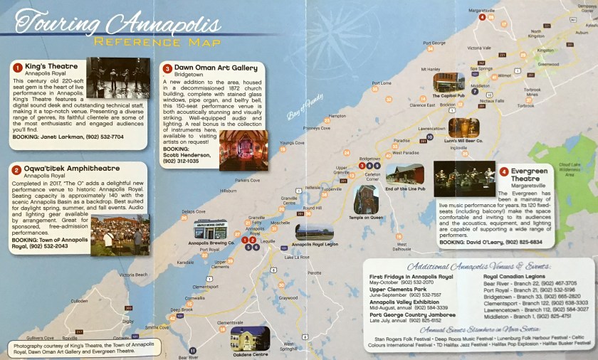 There are several examples of positive outcomes from this relationship e.g. MapAnnapolis, as well as local innovations. This week, I received a copy of Touring Annapolis, Venue guide for Artists produced by Annapolis Venues. It includes a reference map of pubs, eateries and community halls (including Centrelea Cinema).
My suggestion is: take a 15-minute break and listen to each BBC Radio 4 podcast. Look at the new map products and ask the question, can we do more; especially, with regard to the changes which are impacting our landscape and the lives of its inhabitants?
 On the Ernest Buckler front, I want to share a couple of books that crossed my desk this week. Margaret Atwood published Moving Targets, Writing with Intent 1982-2004. It includes two essays that struck a chord.
- Great Aunts. Atwood describes a visit with her Great Aunts to Ernest Buckler’s house in the early ’70s.
- George Orwell: some personal connections. Atwood describes how in 1984 she began writing The Handmaid’s Tale and the influence of Orwell’s books on her writing career.
 The second book is Nova Scotia: Window on the Sea. It combines a text by Buckler with photographs by Hans Weber. While the text and photography can stand alone, it would be interesting to see a map of the photo locations. The book was published in 1973 – forty-six years ago. Perhaps we need an updated photographic version for the fiftieth anniversary.
Acknowledgements
To my brother, Peter, for the link to the BBC Radio 4 podcast series. To Anne Crossman for access to her collection of Ernest Buckler books, To Edward Wedler for his graphics contribution.
References
BBC Radio 4 Podcasts On the Map On the Map
Annapolis Venues Annapolis Venues
Margaret Atwood. 2004. Moving Targets Writing with Intent. 1982-2004.House of Anansi Press.
Ernest Buckler and Hans Weber. 1973. Nova Scotia: Window on the Sea. McClelland and Stewart.
