Tuesday morning I went down to Smith’s Cove to visit David Raymond. David, like myself, had taught at the Centre of Geographic Sciences (COGS). In his case, in the Cartography program; in my case in the Department of Computer Programming. David has invited me to be a speaker at an event planned for Truro, August 14th. It is a workshop on the A.F. Church Historical Maps hosted by the Genealogical Association of Nova Scotia.
Clearly, I have much to catch up on, specifically the topic of Historical GIS. As I undertake my background research, I anticipate a series of blogs on the topic.
In Canada, it is hard to use the term GIS (Geographic Information System) without reference to Roger Tomlinson.
Roger was instrumental in the development of the Canada Geographic Information System (CGIS) initially designed to handle the Canada Land Inventory (CLI) for the federal government. Roger ran a consulting company, Tomlinson Associates from Ottawa. In the 1980’s, as COGS developed training programs in GIS, our paths crossed on many occasions. In the Maritimes, I recall the competition between the CARIS system from New Brunswick (Sam Masry and YC Lee), the STRINGS system used by MRMS in Amherst and the Arc/Info system from Esri in California.
There was a time when new COGS graduates were a pre-requisite for Esri systems as they were installed across North America.
What was a GIS? It was computer software that managed geographic data, portrayed on maps as points, lines and polygons, their associated attributes, as well as imagery (e.g. aerial photographs and satellite imagery). It allowed for a wide range of analyses of both the geography and the related attributes.
COGS was well positioned, with access to survey science, photogrammetry, remote sensing, cartography, planning as well as computer programming.
For a more recent view, I have pulled from my bookshelves three seminal texts.
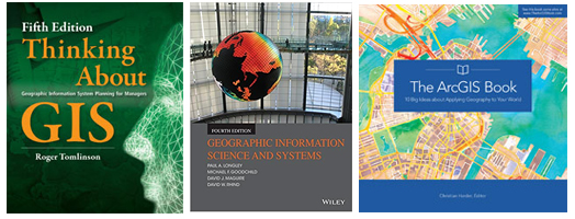
- Roger Tomlinson, 2013, Thinking about GIS: Geographic Information System Planning for Managers (5th. Edition), Esri Press.
- Paul Longley, Michael Goodchild, David Maguire, and David Rhind, 2015, Geographic Information Science and Systems, (4th. Edition), Wiley.
- Christian Harder (Ed.), 2015, The ArcGIS book: 10 Big Ideas about applying Geography to your world, Esri Press.
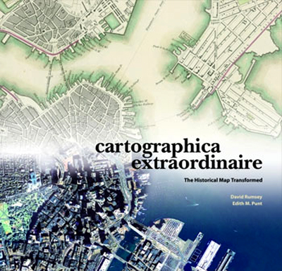
David Raymond lent me his copy of ‘Cartographica Extraordinaire’ The Historical Map Transformed by David Rumsey and Edith Punt. Punt was a Cartography graduate from COGS. She works for Esri in Redlands, California.
From the back cover,
”Extraordinary is the value of this book as a gateway into the Rumsey web site – the chronological listing of all illustrations in the book is carefully referenced to the digital collection on the Internet where users can select their own details”.
David Woodward, Arthur Robinson Professor of Geography Emeritus, University of Wisconsin- Madison,
David Rumsey and Edith Punt, 2004, Cartographica Extraordinaire: The Historical Map Transformed, Esri Press.
Postscript
Please note my references are all before 2015. There have been many new developments in the last six years. Time for more research.
Just returned from the Lawrencetown library, John Higgs’ book, Watling Street, has arrived from the University of Alberta. Travels through Britain and its ever-present past. Recommended by Peter Maher.
Acknowledgements
Thanks to David Raymond for sharing his knowledge and expertise. Edward added the graphics. Edward was Remote Sensing instructor at COGS, contemporary with David and myself.
