Edward has been helping me understand the potential of AI in the conversion of my blogs into geographic topics and locations.
Below, he has used AI tools to identify common themes from over our ten years of blog posts. Based on a quick “digital flyover” of the ErnestBlairExperiment, ten preliminary themes were found. The AI explainer video, below, takes up, for example, the “Maker Geography” theme.
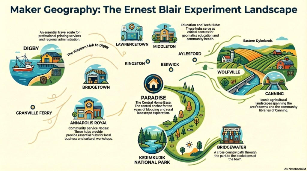
- Maker Geography:
The shift from passive observation to active “making” (art, maps, and community projects). - The COGS Legacy:
Reflections on the Centre of Geographic Sciences and the evolution of Geomatics education. - Plein Air & Extended Memory:
Your journey with art as a way of imprinting landscape onto the soul. - Connecting the Dots:
How disparate ideas—like a walk in Kejimkujik and a technological shift in GIS—are linked. - Community Mapping with Purpose:
Identifying local resources and challenges through the lens of a geographer. - The “Ernest Blair” Philosophy:
Exploring the interplay between George Orwell (Eric Blair) and the local literary spirit of Ernest Buckler. - The Rural Creative Economy:
How hidden gems in Nova Scotia (and beyond) sustain culture and economy. - Technology vs. Ground Truthing:
The balance between high-tech (AI, Lidar, Drones) and the “boots on the ground” reality. - Environmental Stewardship:
Reflections on climate change, the Acadian forest, and “walking the talk.” - A Shared Journey:
The story of a 50-year collaboration between two geographers/artists.
The next step would be to map the post locations and perhaps add interactivity. We hope that this can be achieved in collaboration with the students in David MacLean’s GIS program at COGS.
When we interrogate the COGS LEGACY over all these posts, several defining characteristics emerge.
- Technological Evolution:
- The curriculum at the Centre of Geographic Sciences (COGS) has continuously adapted, now heavily integrating Artificial Intelligence (AI), GIS, and Geospatial Data Analytics to enhance the analysis of complex geographic information.
- Industry Leadership:
- A core component of the legacy is its Industry Expo, an annual event that connects students with major organizations like Esri Canada to address the shifting needs of the geomatics sector.
- Community Integration:
- The legacy is not confined to the lab; it extends into the “human network” of the Annapolis Valley. This is exemplified by initiatives like “community mapping with purpose,” where instructors and students help rural residents map local resources and identify community challenges.
- Academic Stewardship:
- The author’s personal connection to this history is cemented by his role as Geographer Emeritus at COGS, where he continues to document the institution’s impact on the “creative rural economy”.
By putting the AI results in the ErnestBlairExperiment blog, we hope to demonstrate the potential of combining these technologies. As usual, both Edward and I would appreciate any comments and feedback.
Time flies. Next week, Ed Symons hosts ‘ Love where you live’ . A seminar on Community Mapping with his students at CORAH.
This week, there was a rally at the Kings Theatre, Annapolis Royal on ‘Nova Scotia’s Arts, Heritage and Culture’ under threat. I was running late, but did enjoy the videos produced by MapAnnapolis.
The question for our MLA, David Bowlby, centres on the ‘creative rural economy’. In the Annapolis Valley, we are fortunate to attract artists, writers, musicians. This stems from our long history and culture. This, in turn, attracts tourists to the region.
The other unique institutional feature is the Center of Geographic Sciences in Lawrencetown. This provides access to the latest technology in both AI and the Geographic Information Sciences. This should be recognized and promoted at the international level.
