
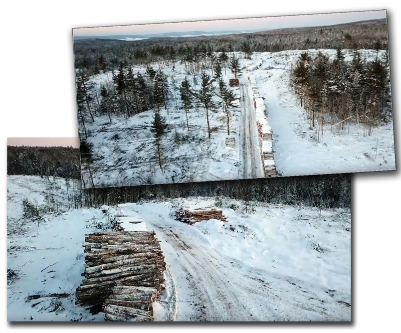
Last Thursday (January 18th), Heather and I decided to go snow-shoeing along the Rifle Range road, off the Inglisville Road. We have been doing this trip for the last fifteen or so years. Imagine our surprise, when we discovered that our outdoor recreation route had been turned into a logging road (see photographs). Curious, we persisted to see what was going on. We found signs that indicated that the parcel of crown land was being logged by a local forestry company, under the WestFor agreement with the provincial Department of Natural Resources.
We took some photographs, and shared our discovery with a few friends and neighbours. Dave Whitman, who also lives on Hwy#201 in Paradise, an author and publisher with his wife Paulette, including books on the ‘lost village’ of Roxbury, mentioned a local photographer, Neil Green. Neil has been experimenting with the use of drones for landscape photography.
This raised many questions in my mind.
- With this new technology, can citizen groups monitor the changes impacting our landscape ?
- Our warden for Annapolis County, Tim Habinski is on record (CBC) about the clearcutting on crown land in the County. Could this technology give us a better picture of the current situation ? And allow, evidence-based decision making ?
- Given the Centre of Geographic Sciences (COGS) in Lawrencetown, would the college be willing to support research in the creation of maps so that citizens could monitor the activities in their own backyard ?
- We own a small, narrow woodlot with our son, Andrew. It runs from the Annapolis River to the Inglisville Road. Could we commission Neil Green or others to fly the property as part of our woodlot management strategy. For example, we could monitor the red maple coppicing by Alex Cole, Little Foot Yurts for yurt poles on Andrew’s parcel. Or we could map the mature hemlocks on the hillside on our parcel, above the Hwy #201.

These questions could lead us to discover new opportunities. With the technology, UAVs, cameras and GPS it is now possible to develop a much better understanding of the landscape, its use or abuse, whether it is agriculture, forestry or recreation. Maybe its time to champion the full value of the landscape. Let us view our environment as something that offers so much more than a simple monetary value ($$$$).
Acknowledgements
Thanks to Heather Stewart for reminding me of our landscape values. Dave Whitman for the connection to Neil Green. Neil for his drone photography explorations. And finally, as usual, to Edward Wedler for his feedback and technology expertise on the web.


