In 1980, the Nova Scotia Land Survey Institute (NSLSI) had programs in Surveying, Cartography, Planning, Photogrammetry.

The arrival of the Scientific Computer Programming (SCP) program brought access to modern computer technology. It included mini-computer systems from Prime and DEC. Shortly thereafter, the Remote Sensing program was applying Dipix image analysis technology, the GIS program was applying Esri Arc/Info technology. Programming students, whether in the SCP program, the Business Computer Programming program or the Computer Graphics program were able to customize these systems to meet the needs of both government and industry partners.
In the world of GIS, digital objects were identified as points, lines, polygons. In the world of Image Analysis, digital objects were identified as pixels and rasters. Digital photogrammetry allowed for the manipulation of aerial photographs. Digital image analysis gave us the same capability with satellite imagery.
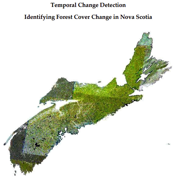
As we move forward from the AF Church maps, we can add images/photographs of the changes in the landscape. We can identify changes in forest cover. How much clear-cutting has taken place on crown land? When, and where? (Image taken from HERE)
We can identify changes in agricultural practices. The removal of Apple orchards in the Annapolis Valley. The increase in the acreage of vineyards.
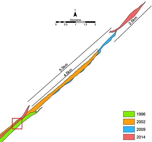
Or we can obtain historical imagery for Sable Island. And identify the changes in the shoreline over the last sixty years. (Image taken from HERE)
The task at hand is to go back to the aerial photograph and satellite imagery libraries whether in Halifax or Ottawa, and to undertake change analysis and marry these changes with settlement patterns and census information. These types of analyses can be undertaken in today’s Geomatics environment.
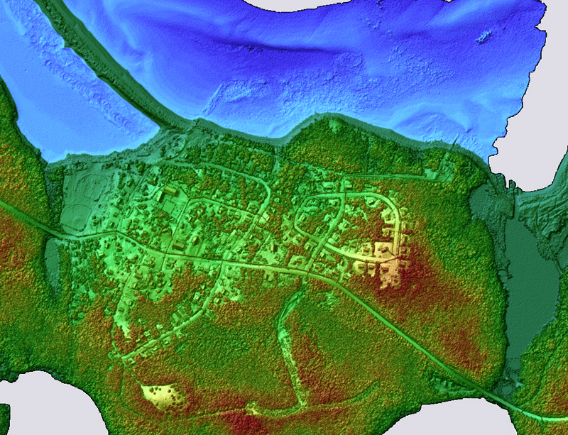
With the availability of LiDAR and other sensors, the results can be analyzed and displayed in three dimensions. In a perfect technological world, we would be able to use a calendar slider that allows us to view the landscape at any particular moment in time, given the appropriate imagery, and the corresponding base maps. (Image extracted from HERE)
Acknowledgements
David Colville provided the link to the Sable Island project. Edward Wedler and John Wightman advised on Remote Sensing.
References
David Colville, Sarah-Marie McDonald, and Suzanne Monette, 2013, (PDF) Temporal Change Detection: Identifying Forest Cover Change in Nova Scotia.
David Colville, Brittany Reeves, Bill Livingstone, Heather Stewart, 2019, (PDF) Mapping the Landscape of Sable Island.
CBC Sable Island undergoing coastline retreat.
AGRG TopoBathy LiDAR website
Postscript
The Truro workshop on the AF Church Historical Maps, Truro, August 14, 2021, includes presentations on Map Conservation, Map Digitization, Geomatics, and Programming.

Bob
Interesting history of mapping technology — would the technology ever advance to the point where land surveyors were no longer necessary? Seems to me like the next step.
A couple of pieces of news — having done nothing on The Book for the past year, I am discussing serialization with Municipal World — some kinks to work out but first piece will appear in December issue.
We have agreed to continue helping Annapolis County Fed of Agriculture and to do so on spec — first order of business is to start finding them some money….
Very busy these days playing catch up on the heritage project we are doing for defence Construction Canada (1814-16 Officers’ Mess at Royal Artillery Park) — it’s about to go into de-construction so decision to be made fast. We should have been on this project a year ago.
Where has the summer gone? (Are you missing apple harvesting?)
Brian
Brian Arnott Principal Novita Interpares | Leaf + Branch
novitainterpares.ca >
LikeLike
I notice that the Lawrencetown arena will be in use this weekend.
Bob
LikeLike