We arrived in Annapolis County in 1980. I had accepted a teaching position at the Nova Scotia Land Survey Institute (NSLSI). It was to teach applications of mapping software in an intensive one year program (48 weeks) in Scientific Computer Programming. Heather and I, with two young boys (Patrick and Andrew), moved from Ottawa (National Museum) to West Dalhousie. We rented what was known as the Ernest Buckler house from Bill O’Neill. He and I commuted down the Morse Road to Bridgetown, and on to NSLSI in Lawrencetown.
After a couple of years, we moved to Clarence East, neighbours to the Barteaux, Elliot and vanRoestel families. In 1988, we moved to Indonesia, California, Ontario (Peterborough) and BC (Victoria) before returning to accept the position of Senior Research Scientist with the Applied Geomatics Research Group (AGRG) at the NSCC in 2000. At that time we purchased a house in East Paradise on Highway #201. Now, in 2026, we have relocated to Middleton.
Throughout our time in Annapolis County, we explored the Bay of Fundy coast, the Annapolis Valley and, to a limited degree, North and South Mountain. Despite our familiarity with the local Geography, we had never been to East Dalhousie.
Given the forest fires last year (see Trial by Fire), I wanted to visit Lake George and Lake Paul. We started out, gassing up the car in Berwick. Moving up onto South Mountain, it is very evident why Berwick is considered the “Apple Capital” of the Valley. From Morristown, we passed through Lake George and Lake Paul reaching the Dalhousie Road, where we turned west to East Dalhousie at the Kings County/Annapolis County line. At East Dalhousie, we turned South on the Cherryfield Road. The Cherryfield community is on Highway #10. Afterwards, we headed North, back to Middleton.
Three significant observations were made on travelling the backroads of Annapolis County
- Access to good maps is essential.
We always have a copy of the Nova Scotia Atlas in the car. In this case, the seventh edition. - The forests of South Mountain are remote and relatively inaccessible.
Given the nature of climate change, there is a high probability of forest fires by lightening strikes. This happened in 2025. The management of these forests is critical, not only for remote communities, but also the proximity to the communities along the mountain slopes — not a time to reduce the resources and capacity of NS Lands and Forests. - It is very evident from the signage on individual driveways that the public, individual land owners, are concerned about the mining of uranium.
Without travelling these back roads, the average politician/ civil servant would not understand the public concern.
A final comment.

The county provides in the mail, “Explore Annapolis County: Your guide to discovery” an excellent publication – BUT NO MAPS ENCLOSED.
The drive through the back roads of Annapolis County was a revelation. And yet, we have known the geography since 1980 (approaching fifty years) on and off, and have been part of the history of the College of Geographic Sciences (COGS).
References
Explore Annapolis County, Your Guide to Discovery, 2026.
The Nova Scotia Atlas 2019, Formac Publishing, 7th edition
Postscript
Edward visited the Annapolis County booth during the recent Saltscapes Exposition in Halifax. At the booth he did get a poster map, “Explore Annapolis County: This is where you wander”. The County marketer told him that the map promoted exploration “Choose your own adventure. Start anywhere. Go everywhere”. In essence it was thematic in nature.
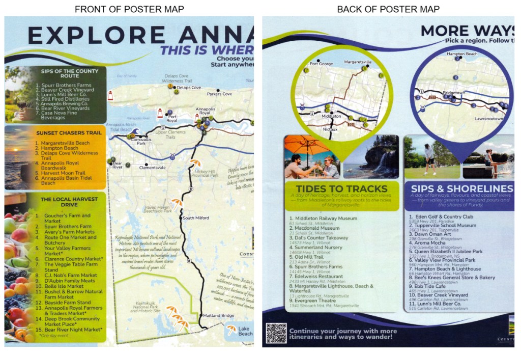
A portion of the poster map is shown, above. A couple of QR codes on the back invite explorers to “Continue your journey with more itineraries and ways to wander”.
