Friday evening, we went to the King’s Theatre in Annapolis Royal to watch Nicholas Cage in Pig.
There was a relatively small masked audience. The film is about a Truffle hunter (Cage) and his pig. It is set in the Oregon forests outside of Portland. The story starts out in the woods and the stealing of the pig. Most of the movie is focused on Cage’s pursuit of the thieves. It also sheds light on the gourmet food trade in the region. In an earlier life, Cage (the character) was a well-known chef.
The film offers insight into authenticity, life on the west coast of the United States and Buddhism.
On the home front, it is time for harvest processing. First, the gooseberries with elderberries jam, then the grapes, and, of course, we are inundated with tomatoes. The 2021 climate has created a bumper season for the different types of berries. And yet, for some reason, our Apple crop is a bust. We are not sure whether lack of pollination or a local pest outbreak. Overall, across the Valley, it looks to be a great Apple harvest.
Acknowledgements
Edward added the links and graphics. Heather shared the processing of the garden fruits.
This weekend, Heather and I were in New Glasgow and Pictou. We stopped in Stellarton to look at an exhibit at the Museum of Industry. It was Colour with a ‘U’, a juried exhibition of quilts on the theme of diversity and inclusion.
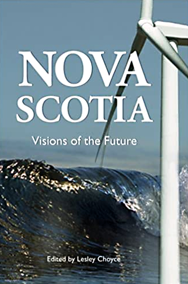
In the gift shop, I purchased Lesley Choyce (ed.) Nova Scotia: Visions of the Future, published in 2009. Choyce invited Nova Scotians to contribute their vision of the future.
”The voices you are about to read are from Nova Scotians who care deeply about the future. There is a passion here for a place and a people.”p.11
”I can’t even begin to imagine what a reader in the year, say, 2029 would make of the ideas here.” p.14.
Here we are, it’s 2021 in a COVID pandemic. We can read the Visions of the Future from over forty voices (from 2009). Many of the voices have passed on.
Later in the weekend, back in Pictou, I found Choyce’s Nova Scotia: Shaped by the Sea, A Living History and, in the same store, Dave Gunning’s Two-bit World recorded at Riverside Studios in New Glasgow.
Over the weekend, from Brian Arnott, a question: ‘Did I know of a map of farms in Annapolis County?’
At that point, I tried to ‘join the dots’. What will Annapolis County look like in 2040?
Certainly, I am noticing changes in agriculture, forestry and the fisheries.
Lesley Choyce had his wish list in 2009.
Clean, renewable, non-nuclear energy for all our needs.
Enlightened, long-term management of all our resources.
Public and institutional enthusiasm for all of our unique cultural endeavours.
An enlightened and generous policy towards immigrants including refugees.
Preservation of our natural wonders.
A cultivated openness to new ideas, alternatives, beliefs and enriching technologies.
Access to education for everyone in the province, and
The fostering of the spirit of cooperation as professed by Father Moses Coady and the Antigonish movement.
It is a moving target. I expect Choyce would have to update his list today.
Acknowledgements
Brian Arnott for his question. Edward, Paul, Frank and others at COGS on the answer. Heather shared family time with the grandchildren at Pictou Lodge. It is their future that is under discussion.
In the last few days, I have become very ‘place-conscious’. Likely, the result of reading The Hermit of Gully Lake.
One of our regular walks is through the old Lawrencetown Forest Nursery, down to the Annapolis River. This week, I noticed that the platform used by the Lawrencetown Voluntary Fire Department to dry out their hoses has been repainted red and black. It should now be visible from the air.
The abandoned nursery is adjacent to the Lunn’s Mill beer company. There would seem to be a potential collaborative business venture. The old nursery could be turned into an outdoor museum, demonstrating the different planting practices over the last several decades. Visitors to Lunn’s Mill could walk, snowshoe or cross country ski the trails, enjoy the outdoor museum, before heading back indoors for a beer.
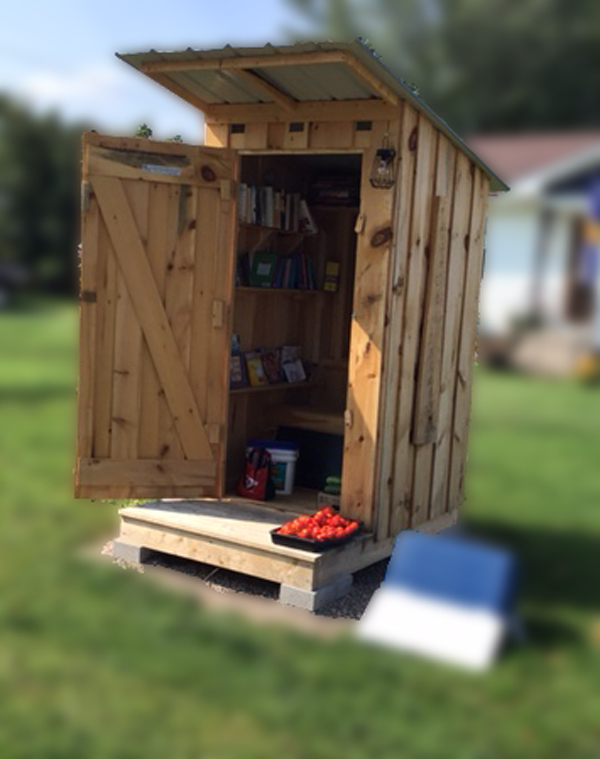
A second observation was the ‘outhouse’ on the front yard at Lawrencetown Lane. In fact it is a free library, with a book exchange, groceries and seasonal vegetables. ‘Take what you need; Leave what you can’.
These mini-library ‘book exchanges’ have popped across rural Nova Scotia. Previously, I had seen them in rural British Columbia, and Scarborough, Ontario.
Before taking the photograph, I stopped to ask permission. The owner, named ‘ Outhouse’, had moved to the Valley from Digby Neck. They had received support from the LifeSchoolHouse group in Clarence for this venture.
These two examples are evidence of the subtle changes that are taking place in rural society, in response to the larger societal shifts.
Acknowledgements
Edward kindly inserted the photographs. Heather shared the walks.
Postscript
I managed to find the first edition of Joan Baxter’s book ‘The Hermit of Gully Lake’ at Endless Shores Books in Bridgetown. It was first published in 2005. There are differences with the new 2021 edition however the story remains essentially the same, about a specific person and a particular place.
I have just finished reading Joan Baxter’s book ‘The Hermit of Gully Lake’, 2nd edition. It is a remarkable story. Sympathetically written and researched. It raises several questions.
The first is a technical one. What have been the changes, if any, between the first and second edition ? I am now trying to track down a copy of the first edition through the Library.
The second is more philosophical. As a Geographer, we talk a lot about ‘a sense of place’. What does a sense of place mean to a hermit? What was special about Gully Lake? Can any place be a ‘special place’ or hermitage?
Willard Kitchener MacDonald ‘jumped from a troop train to avoid going off to battle in World War II and lived for more than half a century in the woods around Earltown in northern Nova Scotia’ p.7.
At about 2 pm on June 27,2004 they found the remains of a ‘deceased elderly man in a wooded area on the east side of Gully Lake’. p.133.
In her epilogue, Baxter quotes the refrain from a song ‘Let him be’ by Dave Gunning and John Meir. I was able to find it online on their CD Two-bit World.
Checking my bookcase, I rediscovered The True Solitude. selections from the Writings of Thomas Merton. Here is an unspeakable secret writes Father Merton.
“Paradise is all around us and we do not understand. It is wide open. The sword is taken away, but we do not know it: we are off ‘one to his farm’ and ‘another to his merchandise’…..’Wisdom’ cries the dawn deacon, but we do not attend’. From the inside of the back cover.
See ”Day of a Stranger” a meditation describes his way of life as a hermit “.
Acknowledgements
Edward added the links and graphics. Heather shares the journey.
Thursday has become “Register-Reader Day”. It is the day of the week to catch up with our community.
From the Annapolis Valley Register (page 8) in these times of Health Services challenge, we see opinions on Diabetes and Dementia. Meanwhile, the Reader gives us a celebration of the life of Kent Thompson. In particular, I recall his book ‘Getting out of town by book and bike’ published by Gaspereau Press, from the back cover,
”Thompson also investigates the role of bicycle in books by writers ranging from DH Lawrence and HG Wells, to Elizabeth Bishop and Ernest Buckler.”
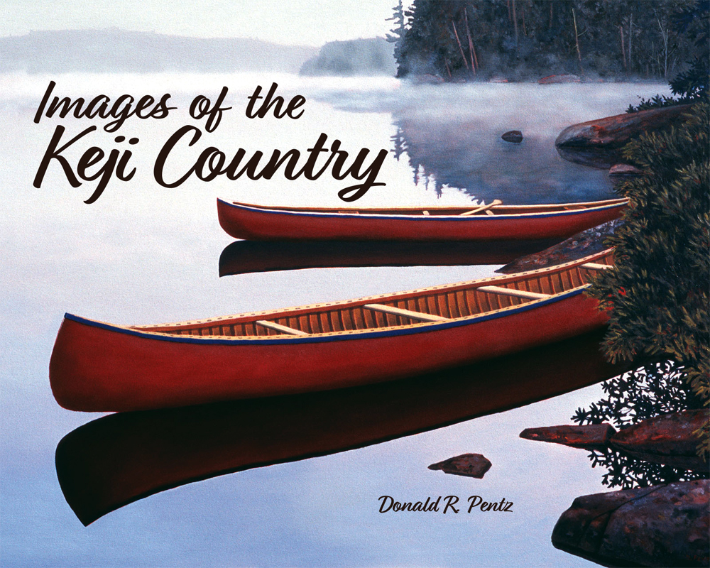
To survive these challenging times, I found a couple of books. At the Inside Story, I spotted Don Pentz ‘Images of Keji Country’.
”Kejimkujik National Park resonates with the distant forces of the Mi’kmaq ancestors. Those voices are given a visual presence through hundreds of petroglyphs rock engravings, the moss-covered fire rings that dot the Keji shorelines and the stirrings of buried artifacts. These things tie the Mi’kmaq to the bold nature of ‘place’.”
“Men frequently say to me, “I think you would feel lonesome down there, and want to be nearer folks, rainy and snowy days and nights especially.”
The book is published by Pottersfield Press. I think that I have a copy of the First Edition but have been unable to find it.
Acknowledgements
Edward added the links and graphics. Heather shared a very busy, tumultuous week.
References
The Annapolis Valley Register, Thursday August 19, 2021, p.8, Diabetes: let’s change the conversation, Brooks Roche, Dementia: Twists and turns on the road to awareness, J. Archibald.
Kent Elgin Thompson. 3 February 1936 – 13 August 2021. The Reader August 20, 2021 submitted by David Thompson.
On Saturday afternoon, I attended the AF Church Historical Maps workshop at the Rath Eastlink Community Centre in Truro. Through David Raymond, I was invited to present the keynote address on Historical GIS in Canada. (Image of AF Church)
In practice, I was able to provide some background on the history of GIS in Canada and some of the personalities. In reality, I was there to learn about the progress to date on the steps in the transformation of the large format late nineteenth century county maps into a digital database to support genealogical research.
The presentations explained four steps in the process.
Julia Landry described the conservation of these county maps. It included the cleaning and repair.
Christian Laforce presented the challenges in the compilation of high level digitization using overhead photography.
The third step was described by David Raymond who used GIS software to geo-reference the images delivered by Christian.
The last presentation on open source programming was scheduled for Shaun Johansen but had to be presented by Paul Armstrong. It described software that would allow the genealogist to link digital data derived from the AF Church maps to the 1881 census.
In the Chronicle Herald (August ,14) there was a half page on E3 ‘Help Us Map Your People’ placed by the Kith Observatory Inc. It confirmed that they have conserved and digitized maps for Antigonish, Hants and Halifax counties. They are seeking help in matching the names and locations on these maps with the 1881 census. They are seeking ‘doers’, ‘knowers’ and ‘benefactors’.
Prior to attending the workshop, I had a very fuzzy notion of Historical GIS. After the workshop, I had a much better appreciation of the practical challenges faced by the Genealogy community in working with the large format AF Church maps, using current technology.
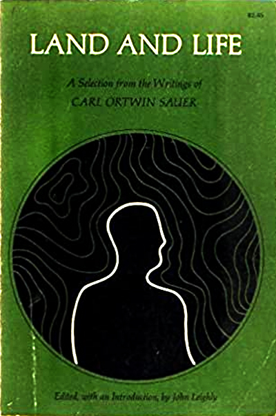
I concluded my keynote, citing the writings of Carl Sauer ‘Land and Life’. By understanding the lives of rural Nova Scotians in the late nineteenth century, we also develop an appreciation of land management in that time frame. That may serve us well, as we move forward.
Acknowledgements
David Raymond for suggesting my participation in the specialist workshop. Paul Armstrong for his work at the Kith Observatory Inc. Edward added the graphics and links.
Carl Sauer, 1967, Land and Life, University of California Press, Berkeley.
Postscript
It is interesting that the acronym GANS stands for both the Genealogical Association of Nova Scotia as well as the Geomatics Association of Nova Scotia. Hope this does not lead to any confusion.
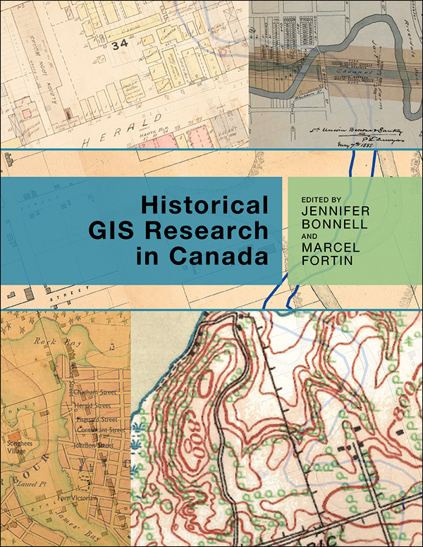
You may be interested in “Historical GIS Research in Canada“, Jennifer Bonnell and Marcel Fortin (eds), University of Calgary Press.
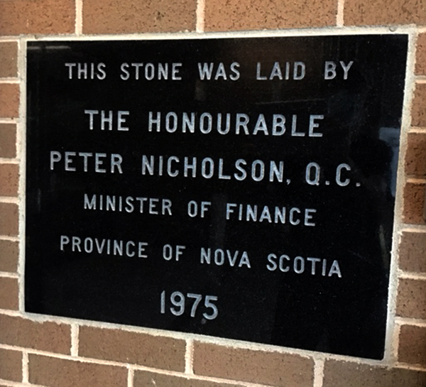
I thought it might offer insights as we approach next week’s Provincial Election. In particular, I was looking to understand the relationship between economic development and ecological landscape management.
I did come across Appendix 2: Top 10 Nova Scotia politicians 1945-2020. (p.236-7). This included: ”Peter Nicolson MLA 1956-1978. Finance Minister 1970-78. Set the gold standard for ministers. Smart, respected.”
This in turn, reminded me of all those days that I walked through the front doors of NSLSI (COGS) and view this plaque.
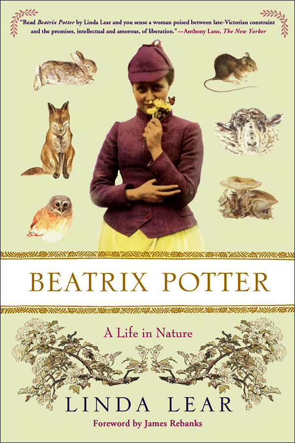
I have just started this lengthy tome (584 pages). I am encouraged by the map of Beatrix Potter’s Lakeland 1892-1943. And from the first sentence in the Acknowledgements (p.ix).
”Beatrix Potter was first of all an artist and writer of place who found her personal and intellectual freedom in nature. She later became a conservationist in an effort to preserve the landscape that had inspired her art.”
This week, too, I am preparing for the AF Church Historical Maps Specialist workshop (see previous blog post). I am charged with the following topics
outline the development of Historical GIS in Canada;
discuss the prospects for development of this technology in Nova Scotia.
To speak to the first topic, we must explore the history of GIS in Canada and elsewhere. For the second, we must visit technological development in Nova Scotia and beyond.
Since the invitation to speak at the workshop in Truro, I have used my blog: ernestblairexperiment.wordpress.com to reflect on both topics.
After the workshop, I hope to be in a better position to comment on current directions, within the context of the AF Church maps.
Acknowledgements
David Raymond initiated the workshop process and provided the link to “GIS Applications in Human Geography“. Edward Wedler added both his technical expertise and insight into Remote Sensing.
In 1980, the Nova Scotia Land Survey Institute (NSLSI) had programs in Surveying, Cartography, Planning, Photogrammetry.
The arrival of the Scientific Computer Programming (SCP) program brought access to modern computer technology. It included mini-computer systems from Prime and DEC. Shortly thereafter, the Remote Sensing program was applying Dipix image analysis technology, the GIS program was applying Esri Arc/Info technology. Programming students, whether in the SCP program, the Business Computer Programming program or the Computer Graphics program were able to customize these systems to meet the needs of both government and industry partners.
In the world of GIS, digital objects were identified as points, lines, polygons. In the world of Image Analysis, digital objects were identified as pixels and rasters. Digital photogrammetry allowed for the manipulation of aerial photographs. Digital image analysis gave us the same capability with satellite imagery.
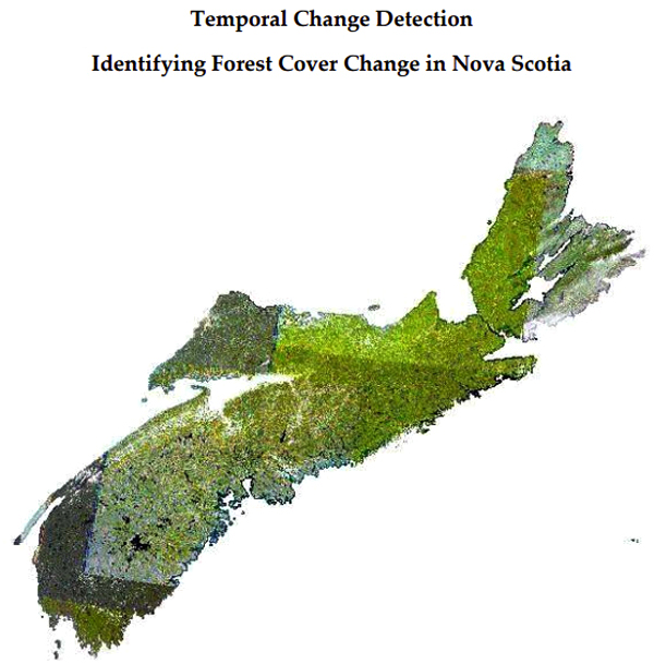
As we move forward from the AF Church maps, we can add images/photographs of the changes in the landscape. We can identify changes in forest cover. How much clear-cutting has taken place on crown land? When, and where? (Image taken from HERE)
We can identify changes in agricultural practices. The removal of Apple orchards in the Annapolis Valley. The increase in the acreage of vineyards.
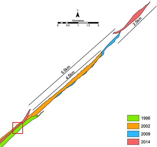
Or we can obtain historical imagery for Sable Island. And identify the changes in the shoreline over the last sixty years. (Image taken from HERE)
The task at hand is to go back to the aerial photograph and satellite imagery libraries whether in Halifax or Ottawa, and to undertake change analysis and marry these changes with settlement patterns and census information. These types of analyses can be undertaken in today’s Geomatics environment.
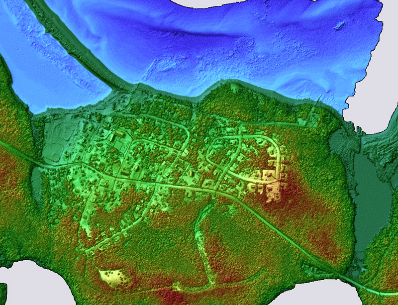
With the availability of LiDAR and other sensors, the results can be analyzed and displayed in three dimensions. In a perfect technological world, we would be able to use a calendar slider that allows us to view the landscape at any particular moment in time, given the appropriate imagery, and the corresponding base maps. (Image extracted from HERE)
Acknowledgements
David Colville provided the link to the Sable Island project. Edward Wedler and John Wightman advised on Remote Sensing.
The Truro workshop on the AF Church Historical Maps, Truro, August 14, 2021, includes presentations on Map Conservation, Map Digitization, Geomatics, and Programming.
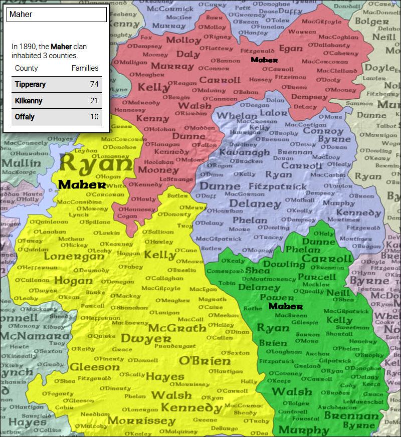
In preparation for a presentation at the specialist workshop on AF Church Historical Maps in Truro on August 14, I checked with David Raymond on his current definition of ‘Historical GIS’. In return, he sent me a link to a product developed by Esri’s StoryMaps team ‘Mapping Irish Surnames ‘. Of course, I could not resist keying in my surname, Maher.
In 1890, the Maher clan inhabited three counties.
County Families Tipperary 74 Kilkenny 21 Offaly 10
The Church maps give us cartographic coverage for Nova Scotia. The maps show us the existing road infrastructure, schools, churches, stores, mills, post office etc.. ln addition, there is the location of houses with the owner’s name.
Put in GIS terms, we have a point coverage (house location) and attributes (owner name). We could create a point layer (owner name) and also a polygon layer (county). This would allow us point in polygon analysis, thereby replicating the functionality of the Irish Surname project.
There are a number of GIS/Cartographic challenges. We must ensure that the map layers in the GIS all adhere to the same reference system and projection. This would ensure that the buildings are in their correct position on the earth’s surface, and that they lie within the correct county boundary.
The challenge for the attendees of the workshop will be to consider other features/content of the AF Church maps which can be studied within a GIS context (e,g. other infrastructure – mills, stores, hotels churches etc., plus other historic sources which can be geo-referenced to a modern representation of the Church maps.
In a follow-up blog, I will consider other data sets which may help us understand the changes in landscape, as the result of changing settlement patterns and land use. This will reflect changes in cartography, GIS technology and other new technologies such as drones, LiDAR, ground-penetrating radar.
Acknowledgements
Thanks to David Raymond for sharing his knowledge and links. Edward Wedler, John Wightman and others, reflected on the availability of historical satellite and aerial photography.
On Friday, I went to COGS to drop off a couple of library books. The building was deserted, and COVID protocols were in place. I did manage to spend time in the Board Room to look at the maps from the W.K.Morrison Special Collection. Walter joined the NSLSI as a Cartography instructor in 1966. He retired in 1985.
I had the opportunity to look closely at the eighteenth century nautical charts of DesBarres’ Atlantic Neptune, as well as the Herbert Moll map 1736-45 that shows the location of Annapolis Royal.
Perhaps for the first time, I fully appreciated the geographic content, the workmanship and creativity in design. Cartography is a wonderful combination of both scientific and artistic endeavour.
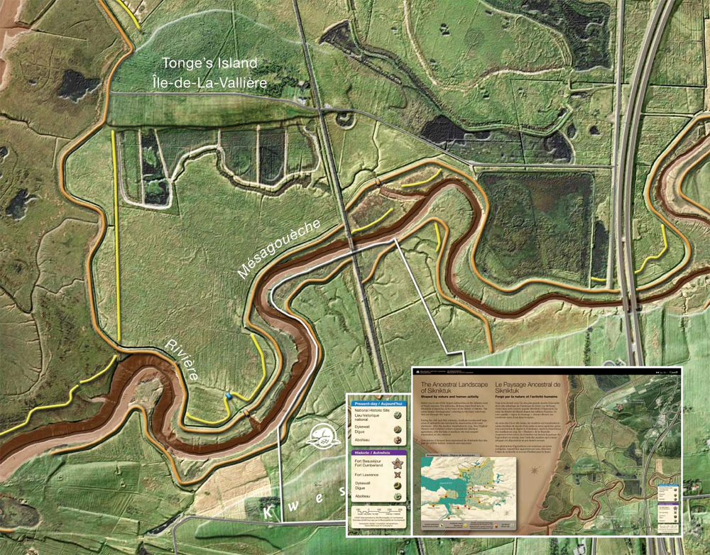
Ancestral Landscape of Sikniktuk
On the ramp leading to the Library, outside the AV Room, there is a stunning modern day exhibit of the maps by Marcel Morin, Lost Art Cartography. Maps include Wines of Nova Scotia, Landscape of Grand Pre, the Ancestral Landscape of Sikniktuk and the eighteenth century trade at Beaubassin.
In these maps, Morin adds three dimensional representation of topography derived from LIDAR. Again, a modern example of scientific and artistic integration. Morin is a graduate of the COGS Cartography program, living in the Annapolis Valley.
ACRONYMS
In the late afternoon, I joined John Wightman for a beer. We talked about the story behind the different acronyms.
COGS: College of Geographic Sciences
This was invented in 1986 to replace NSLSI. With the formation of the NSCC, it became the Centre of Geographic Sciences. John liked the concept of cogs in a wheel. The different disciplines working together to drive forward an engine or machine. Again, the combination of artistic design, science and the enabling technology.
CANMAP
Another JFW invention. It stands for Canadian Numerical Mapping Applications. This suggests the use of computer technology, a focus on applied science, and a uniquely Canadian perspective. CANMAP has traditionally supported student graduation awards at COGS.
AGRG: Applied Geomatics Research Group
AGRG is located at the Middleton site of the Annapolis Valley NSCC campus. Again the acronym suggests a focus on applied science, using Geomatics technology, undertaken by a group of researchers.
These acronyms reflect the values and interests of a community of individuals, based in rural Nova Scotia, Lawrencetown. There are , of course, many side stories. For example, the establishment of a similar program, modelled on the COGS curriculum in Indonesia. Or the relationship between COGS and the Environmental Systems Research Institute (ESRI) in California.
John Wightman for his memories of NSLSI and COGS. David Raymond for encouraging a closer look at the WK Morrison Special Collection. Edward and Heather for their ongoing support.
VISIT COGS ! Preferably, once the students and faculty have returned in September. Check out the Story of COGS web site.