Posted in New thinking, Opinion

Maps from an animal’s perspective

We often talk about geography and the land from a human perspective. What about from an animal’s perspective?
How do they understand the land? They do not use our compasses and maps but must understand landmarks, boundaries and “sense”.
I think of the resilient service sledding dogs offer to travel in the North, such as those shown here on Andrew Maher’s recent trip.
dogsledTeam_Apr2018_750w90dpi
I think of migrating caribou and how they are impacted by human interaction.
I think of the industrious beaver and how their drive to “use the land” is different from our “land-use”.
I think of the wolf — how we “re-introduce” species and we learn, serendipitously, over time how important they are to the health of the (ours and theirs) ecosystem and physical geography.
Bob’s past posts on clearcutting highlights, for me, our insensitivities; placing our needs to strip bare our land ahead of animals’ needs of land to maintain their livelihood and form basic shelter and protection.
dawsonOnMoshersIsland
As an experiment, I decided one morning to carry a video camera at knee height (my dog’s eye view)  for almost an hour as I walked an island in The La Have area of Nova Scotia (this was no easy task). Upon review, I was intrigued to experience the world’s perspectives, vistas, obstacles, nooks and crannies as my dog saw them.
And, what would maps look like if crafted from an animal’s
point of view?
Posted in Book Review, New thinking

Up Here: the Voice of Canada’s Far North

As I fly from Ottawa to Iqaluit, I notice my free copy of “Up Here” magazine in the seat pocket in front of me. After a few days, hanging out indoors, waiting for a blizzard to die down, I start to read back issues of the magazine. upHareMagCover_Aug2015The August 2015 issue had an article by Tim Edwards (p 42-50) entitled ‘From the West to the Wilderness‘.

“Europeans arrived in North America looking for wealth and the Pole. Explorers defied death for glory. What drives today’s adventurers ?”

The article begins with the Franklin Expedition, and then talks about Frederick Cook and Robert Peary “who were welcomed as kings by governors and the public alike, as they stopped In various ports on their way home from the North Pole.”

“Now the world is mapped and the heroes of old are long in their graves. When people go missing in the High Arctic, we consult SPOT trackers, we send out search and rescue missions that last days, not years.”

“Sarah McNair-Landry and Erik Boomer and their dog team spent 120 days circumnavigating Baffin Island. Their goal was to retrace a journey by McNair-Landry’s parents took twenty-five years earlier.”

“Gear and communications are leagues above what it used to be. When Franklin’s ships were lost, other ships were commissioned to follow the route and find the crew – who were stuck in some unknowable corner of the Arctic Archipelago – at their own peril.
Today adventurers have SPOT and InReach devices, satellite phones and helicopters can extricate them from tight spots.”

Today, 2018, with new underwater technology, the wrecks of the Erebus and Terror have been found. Many books have been written on Arctic exploration and its historical context, whether from the European or American point of view. A new history is being written by modern-day adventurers, combining traditional transportation and knowledge, with modern technology, and from a variety of disciplines.

“Whereas early explorers brought European society to the Americas and 20th-century explorers were out to leave a  legacy and gain high esteem. Today’s explorers are mostly unknown outside adventure travel circles, looking for not much more than to leave society and experience the world in its natural state.”

REFERENCES
Up Here. The Voice of Canada’s Far North. Published by Canada North Airlines.

Specific back Issue. August 2015. Article by Tim Edwards. From the West to the Wilderness. p. 42-50.
Check Canadian North web site for upnorth.ca

For US perspective,
Michael F. Robinson. 2006. The Coldest Crucible. Arctic Exploration and American Culture. University of Chicago Press.

There are many books written about the European perspective on Arctic exploration and the prevailing European culture.

FOOTNOTE
blog_01a
Today, my son headed out for a four-day trip via dogsled team, across sea ice and through a blizzard. Garmin technology allowed him to track and relay his position, average speed, distance traveled, maximum elevation, and time, and send-receive text messages. As I was unable to access these via my computer, I worked with Edward in Nova Scotia to relay that information back to me.
As noted by the Up Here magazine writer, Tim Edwards, “Gear and communications are leagues above what it used to be.

Posted in New thinking, Opinion

Can maps do a better job in our back-yard?

If the technology exists to instantly light up our phones when our village has been hit in the game “Clash of Clans” surely we can work to do the same when our land/water/air is being impacted in real-life.

clashOfClansClearCut
With the many technical advances these days maybe we need to set aside or identify tracts of land where we research ideal mapping practices — maps that readily and fully inform and seamlessly engage us, citizens.

Sure, Google has made mapping strides with easy access to street view, traffic assists, and feature identification. Many of us use these maps. ESRI lets us, not as easily, mash databases and tell stories to create personalized maps. Fewer of us use these maps. I suggest, however, that maps can reflect a larger part of our DNA when they subsume social-media/market value. We need to explore the real market potential for interactive, immersive, and adaptive maps.
As I have been south this season and have read many of Bob  Maher’s blogs I have been pondering as to WHO, these days, most interacts with the natural landscape and HOW we interact with it, and of the role of maps. Seeing forest clear-cuts first-hand, for example, contrasts drastically with viewing them on a screen, days/weeks/months later. If we could better connect maps with our daily lives we could find greater transparency of forestry and other practices or issues.
If game developers can market and make b/millions with “what if” scenarios and if we can be tweeted, poked and notified instantly then surely we can create maps to do do the same for us citizens. Can we improve maps by better connecting them via social media network for all stakeholders and citizens?
Maybe, Bob and Heather who live in Paradise, Nova Scotia would not have had to discover, with surprise, that their “back-yard” had been violated with forest clear-cuts.
Posted in New thinking

The Nunavut Landscape: maps and dreams

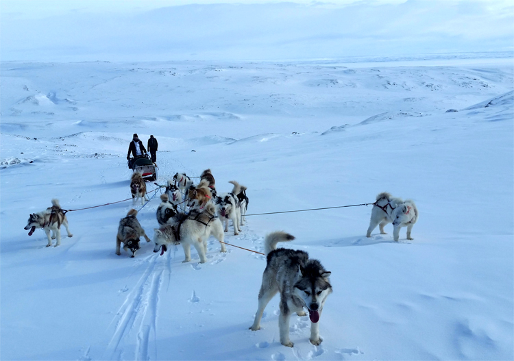
Every Spring, Heather and I head North to help with grandchildren. Andrew takes off on multi-day dog sledding trips and often Julia has to lead school trips to the South. This year, since the end of February, I have spent time in England, Nova Scotia and soon, Nunavut. This blog completes a trilogy on the landscape: the Royal Landscape of England with its emphasis on commodity and property; the Nova Scotia landscape with the emphasis on the harvesting on Crown land; and now the landscape of Baffin Island.

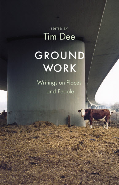
In the latest Guardian Weekly, Katharine Norbury reviewed a new book by Tim Dee, Ground Work: a collection of writing on places and people.

groundwork

One of the essays is by Hugh Brody. In the words of the reviewer:

“Hugh Brody in meditation on the idea of home recounts his experiences of mapping the northern Baffin region of the Canadian Arctic to show all the places in which Inuit have hunted for seal, walrus, narwhal, caribou, hare and polar bear. He records the places where they gathered blueberries, cranberries and the eggs of Arctic terns. And to what purpose ?”

“To develop a legal basis by which the Inuit people might lay claim to the land that has sustained them  for millennia.”

As Norbury concludes, ” one does not need to be a farmer, or a conservationist to justify a relationship with the wild. We just need to learn to look properly, and to find the common ground”.

Imagine if Hugh Brody and others had conducted similar studies with the Mi’kmaq in Nova Scotia. Would there be a different attitude towards the land? Heather Stewart had the idea that we take the work of Dave and Paulette Whitman and map the history described in their first chapter, The Mi’kmaq of Paradise and Area. Or we could research the name, Eel Weir Lake; or talk to Roger Lewis at the Nova Scotia Museum about the location, construction and importance of eel weirs to the nomadic culture. Another resource would be the book by Trudy Sable and Bernie Francis The Language of this Land, Mi’kma’ki.

From our time in Haida Gwaii, we know that the Haida culture was instrumental in stopping the logging of old growth forest on the island and along the coast of Northern British Columbia.

This week, reading Lesley Choyce Seven Ravens, I was reminded of the importance of raven to the Haida. Choyce tells the story of walking from the south shore inland until he has seen seven ravens. He then ends his journey and turns back for home.

mapsAndDreams

Maps and Dreams is the title of Brody’s classic book. We can still dream about other cultures and the way they understand the landscape. We can still think about maps which help us find our way through the wilderness.

Now I am ready to see the changes in Iqaluit: to the landscape, the buildings and the people.

Thanks to the Road to Georgetown team. Heather Stewart for sharing in many of the ideas and experiences; likewise Edward Wedler for his creative input.

References
Tim Dee. 2018.  Ground Work: writings on places and people. Jonathan Cape.

Katharine Norbury. 2018. Wonder all around us. The Guardian Weekly 09.03.18. p. 36

Dave and Paulette Whitman 2016. The Valley Chronicles. Tales of the Annapolis Valley. Bailey Chase Books.Paradise.

Trudy Sable and Bernie Francis. 2012. The Language of this Land, Mi’kma’ki. CBU Press.

Lesley Choyce. 2009. Seven Ravens Two summers in a life by the sea. Wolsak and Wynn.

Hugh Brody 1992. Maps and Dreams. Douglas and McIntyre.

Roger Lewis is  Curator of Ethnology at Nova Scotia Museum


Posted in New thinking

The Nova Scotia Landscape: returning to forest cutting

Two months ago (January 18th), I wrote a blog about the cutting of Crown Land on South Mountain in the Inglisville area. As the result of some recent questions, it was time to revisit the Rifle Range road to Eel Weir Lake. With minus ten degrees centigrade and some fresh snow overnight, it was a perfect day for cross-country skiing.

There has been significant new cutting closer to the rifle range. Indeed part of the property, designated as a buffer to the rifle range, has been harvested. The stacks of both hardwood and softwood are higher and longer.


From the perspective of citizen science, a logical next step would be to contact Neil Green again and see if we could conduct another drone flight over the site (see earlier blog video).

After that previous blog, I contacted David Colville at COGS. He identified two relevant websites to explore. The first was the provincial Harvest Plans Map Viewer which shows the locations of the cuts. The second was the Global Forest Watch site at the University of Maryland which shows the history of forest change from satellite data since 2000.  Both of these sites are relevant in terms of a fact base for decision making.

Let’s sidestep for a moment. My second update relates to my recent visit to England. While there, I was referred to the writing of George Monbiot. On returning home, I received a new subscription to the Guardian Weekly. Lo and behold, on the back page of the March 2-8th edition, Monbiot has a column on the town of Frome in Somerset. It is entitled:

“One UK town has discovered a potent cure for illness – community. Frome’s dramatic fall in emergency admissions to hospitals should be a lesson for all of us”.

Or take his final paragraph:

” In other words, the evidence strongly suggests that social contact should be a prescription, as it is in Frome. But the silo effect, budget cuts and an atmosphere of fear and retrenchment ensure that precious little has been done.”

Sound familiar!

Let us join the dots. Healthy community engagement is a positive force in rural parts of England and Canada. We can learn from each other. Citizens can help make sure that decisions about the health of our landscape and the health of citizens are based on verifiable facts, rather than political expediency.

Let’s give the final word to Sharon Butala:

See her article in The Walrus.

“Against Ageism. It’s time to stop treating senior citizens as a burden”.

Or in the words of Rachel Carson:

“The real wealth of the Nation lies in the resources of the earth – soil, water, forests, minerals and wildlife. The administration is not properly, and cannot be, a matter of politics.”


References

George Monboit. One UK town has discovered a potent cure for illness – community. Frome’s dramatic fall in emergency admissions to hospitals should be a lesson for all of us. The Guardian Weekly. 2-8th March 2018

Sharon Butala. Against Ageism. It’s time to stop treating senior citizens as a burden. The Walrus Vol.15 Number 3 April 2018. p 15-19.

Thanks again to Heather Stewart for the photographs and support, and Edward Wedler for the graphics manipulation. I take full responsibility for the words.


Posted in New thinking

Neither Black nor White: shades of grey

08Feb18_goldIn Saturday’s Chronicle Herald, Bill Black wrote an opinion column “How can rural NS prosper without resource extraction ?” and Joan Baxter (White) wrote ” For rural residents, all that glitters is not gold”. This resulted in the following Letter to the Editor.

Black’s last paragraph states:

“Those who want strong rural communities, but want to abolish all mining and quarrying, marine-based salmon farms, oil and gas development, and paper mills are invited to explain how they imagine those communities can keep their young people and thrive.”

I accept the challenge, although I don’t see it as an either/or proposition. Those of us who live in rural communities seek to manage our landscape, without compromising its long term value.

In this corner of rural Nova Scotia, Annapolis County, we have recognized that the management of our natural resources can be achieved through the provision of high quality education and research. Last week, I was once again reminded of this fact when the Centre of Geographic Sciences (COGS) and the Applied Geomatics Research Group (AGRG) hosted a two day workshop on three dimensional data; its collection, analysis and visualization. ( see my previous blog for a more detailed discussion,  or go to https://geomatics.one for the workshop agenda).

This type of alternative educational model can assist in the identification of rural economic development issues, supports rural communities, and offer technology/science solutions that can be exported world wide. It is not unique to this part of rural Nova Scotia. But it does require different thinking, away from the either/or approach as presented by Bill Black.”

I received a positive acknowledgement from the Chronicle Herald.

One further footnote related to the title of Joan Baxter’s piece. There are many ‘nuggets of gold ‘ out there in the rural landscape of Nova Scotia: individuals and groups, with wonderful stories, ideas and dreams.

Finally, I want to acknowledge the intellectual support, and technological savvy of Edward Wedler.

References

The Chronicle Herald. Saturday February 3, 2018 Page: E3

Bill Black. How can rural NS prosper without extraction?

Joan Baxter. For rural residents, all that glitters is not gold.

Posted in New thinking

A Canadian University of Geographic Sciences.

My last blog looked at the Smart ICE project and its implications for other parts of Canada. This has led to a number of realizations, concerning the role of post-secondary educational institutions and today’s technology in a global context.

In 1986, we redefined the Nova Scotia Land Survey Institute as the College of Geographic Sciences. We dropped the provincial epithet and expanded from land surveying to geographic sciences. Geographic Sciences included Cartography, Remote Sensing, Geographic Information Systems (GIS), Community Planning, as well as the associated computer programming and technology (the story of COGS )

By 1996, COGS had become a part of the autonomous Nova Scotia Community College (NSCC). COGS was redefined at a Centre of Geographic Sciences. In this same time frame, in the United States, with NSF funding, Drs Goodchild, Marble and Frank had established the National Centre for Geographic Information and Analysis (NCGIA). It was a network structure including UC Santa Barbara, SUNY, Buffalo and University of Maine, Orono. Elsewhere, in Europe, UNIGIS was offering online programs in the Geographic Sciences.

CanadaNetworkImagine the following scenario, COGS could have been expanded to form a network of campuses of the University of Geographic Sciences (UGS). This would permit technical resources to be applied to a wide range of geographic issues across the country. It would build on Canada’s history of innovation in Remote Sensing and GIS. Today, we could use the network to understand a wide range of geographic issues by monitoring and modelling different conditions. Smart ICE would be one example. We can imagine other contributions to our understanding of the boreal forest, or ocean management. Because of the geographic extent of the country, there are many opportunities to observe changes in land, sea and air. This natural laboratory, supported by a network of technical institutes could provide insight and offer solutions to a number of pressing global issues: climate change, urbanization, alternative energy sources.

On the cultural front, Canada has access to a multitude of views of the land, sea and their associated resources. This can be generalized, as a diversity of interest in community mapping.

It is not too late to build a National University of Geographic Sciences (UGS). Part of the network would include campuses in the Arctic and Boreal Forest.

What would be the technologies today ?

  • Geographic Information Systems
  • Remote Sensing
  • Sensor networks
  • UAV’s (drone technology)
  • Cartography
  • Community Mapping
  • Survey Engineering
  • Information Technology
  • Place-based Artificial Intelligence

What would be the sciences/systems today ?

  • Climatology
  • Geomorphology
  • Biogeography
  • Oceanography
  • Computer Sciences

Summary

Canada, with its geographic extent, diversity of landscapes and cultures, continues to offer the opportunity to study and understand the condition of our global systems. By investing in a National post-secondary technical education network, the country would be making a major contribution to our understanding of these global systems, but also, be supporting the well-being of its citizens in this dynamic global environment. It would be efficient in terms of costs, speed/catalyst of innovation and degree of ingenuity.

Time to step up to the plate.

Posted in New thinking

Smart ICE and rural Nova Scotia

On January 4th, the CBC program, The Current aired a segment entitled “As ice thins underfoot, technology is combined with traditional Inuit knowledge to save lives “. (see podcast)
It describes the Smart ICE project,  a collaboration between Northern Inuit communities and Southern science at Memorial University of Newfoundland (MUN). The podcast interviews Dr. Trevor Bell, Department of Geography at MUN, Shirley an Inuit resident from Arviat and Glen Aikenhead, an educator from Saskatchewan. The project emphasis is on the safety of Inuit travelling on land fast ice along the flow edge. It involves permanent monitoring stations,, mobile platforms to measure ice thickness as well as community knowledge of sea ice travel conditions around Northern communities.

The discussion centred on the need to combine specific place-based knowledge with more generalized scientific understanding.

This collaborative model offers many lessons for rural Nova Scotia (and other parts of Canada). It emphasizes a sharing of knowledge about the land. The importance of this knowledge to relationships and survival in these communities. The adoption of new technology by Inuit youth and their role in the community.


In rural Nova Scotia,we have many culturally isolated communities) Acadian , Mi’kmac, Black Nova Scotian. We need to adopt mechanisms for sharing geographic knowledge about the land, including climate change, water quality and forest cover. We need permanent monitoring stations, mobile platforms for accessing community knowledge. One example is the network of climate stations established by David Colville, while he was employed at AGRG. We need to share this information and develop relationships between community groups. In the Smart ICE project, the communities define the problem and later, they implement the solution.

eyeballOnNSmap
“Seeing Nova Scotia” image courtesy of Edward Wedler

Community Mapping offers a forum for sharing place-based knowledge and placing it alongside a broader scientific context. As in other parts of Canada, we can all benefit from ‘two eyed seeing’.

For a different take, on the same issue, see Gary Snyder, A Place in Space.p.250.

” We are all indigenous to this planet, this mosaic of wild gardens we were being called by nature and history to reinhabit in good spirit. Part of that responsibility is to choose a place. To restore the land one must live and work in a place. To work in a place with others. People who work together in a place become a community, and a community, in time, grows a culture. To work on behalf of the wild is to restore culture.” October 1993.

Posted in New thinking

Apple Pickings

At this time of the year, in early September, there comes a moment to decide whether the number of apples dropping in our organic orchard justify moving into full time harvest mode. For the last ten years, we have been custodians of an orchard planted by Raymond Hunter in the early 1990’s. Raymond was an early organic farmer in the Valley.

Last year, we picked fourteen bins. It takes eighteen boxes to fill a single bin. The apples come from ninety one trees; four varieties: NovaMac, MacFree, Liberty and NovaSpy — all scab free. We arranged for Brian Boates in Woodville to pick up the fourteen bins on a flat bed, and then to juice the crop. The juice was transported to Ironworks distillery in Lunenburg, where Pierre Guevremont is turning it into apple brandy. It will be another year before we can sample the result.This year, so far, we have picked five bins. It looks like the yield will be less this year. The size of the harvest depends on pruning, pollination and microclimate. This year we pruned the higher branches to make for easier picking. We have had a dry, warm Summer. Less water likely affects the number and size of the apples.

Besides picking for brandy production, we have invested in a hand grinder and press. Last year, we borrowed the equipment from the Community Gardens in Annapolis Royal. This lets us produce small batches of sweet cider (apple juice). There may be a business opportunity here. I can envisage a mobile unit travelling throughout the Valley to relic orchards. The apples could be collected, allowed to ripen, and then pressed into sweet cider. With different varieties, we could then experiment with the effect of apple variety mix on taste and quality. A further step is to use the juice to make hard (alcoholic) cider for personal consumption.

Future considerations include the addition of organic fertilizer (earthworm castings), drip irrigation in dry years, the addition of beehives for increased pollination. These thoughts are my brain pickings from the orchard.

References

Every Sunday morning, I receive a blog from Maria Popova; Brain Pickings (brain pickings).

Posted in New thinking

The Geographic Sciences and Regional Development

Imagine you are a movie maker, and you have been charged with marketing the Annapolis Valley.

You discover that the Centre of Geographic Sciences (COGS) in Lawrencetown has world-class expertise in the application of geomatics technologies to geographic issues. Given the current state of these tools, how could your movie be enhanced ?
digitalAnnapolisValley_02
First, by Geographic Sciences, we include a range of methodological tools. Historically, this would be map making (cartography) and the interpretation of aerial photographs. Today, we would expand the list to cover a wide range of remote sensing (e.g. satellite imagery), the use of unmanned aerial vehicles (UAV) or drones, networks of climate sensors, as well as airborne and bathymetric LiDAR. We would include Geographic Information System (GIS), software which permits the integration of multiple layers of geography in a digital and web-based environment. At COGS, there are also other complementary programs in Surveying, Planning and IT.

Given this rich array of technologies, how might COGS assist in marketing the Annapolis Valley geography?

  1. We could ensure access to high-quality maps. This might include historic maps from the Walter Morrison collection. It might include early satellite imagery showing the changes in the land cover in the region, e.g. agriculture and forestry.
  2. Since Cartography is also a digital science, we would want to ensure the best quality design for display both on-line and in a traditional paper format.
  3. GIS is an integrating technology. It allows the viewer to interrogate the landscape on many levels at the same time. For example, we could have an interactive map of the Valley. The user could identify transects across the landscape and then move the cursor along the transect. Whenever there was a change in soil, land cover or geology, a window would pop up with the details. Or imagine hovering over a place name and a pop up shows you the demographic profile and other economic facts about the community.
  4. Another feature of GIS is the ‘story map’ concept. To explain the diversity of residents in the region, we could create a point layer (dots) of video interviews in the Valley. Each dot would be classified or coloured, according to the type of interview e.g. topics, age group of the interview subject. Click on the dot and watch the video or listen to a podcast.
  5. The combination of GIS and Remote Sensing allows the user to ‘fly through the landscape’. The topography can be seen in three dimensions with current imagery draped over the surface. We could create a series of ‘fly through’ transects from South Mountain to the Bay of Fundy, at Annapolis Royal, Middleton, Kentville, Windsor.

By combining modern film techniques from different airborne vehicles, delivering high quality online cartographic products and experiences, we could showcase innovative Valley regional development. Our stories become embedded into the digital landscape.

I challenge our citizens and communities, then, to market the Annapolis Valley through geomatics technologies, the type we have at COGS in Lawrencetown, as a part of our economic development, tourism and heritage-building process and build our quality of place.

Thanks to Edward Wedler for his creative graphic and comments on earlier draft.