Wallander is a BBC production, available on the CBC channel, about a detective solving murder crimes in Sweden. It combines problem-solving (joining the dots) with personal life issues, set in a rural landscape. This scenario reminds me of living in rural Nova Scotia and attempting to understand the day to day political culture.
The Rural Innovation District (RID) fund is one of three funds administered by the NSCC. The other two funds are designed to address innovation ecosystems in metro Halifax and Cape Breton. The ‘rural district’ refers to the geography of all of rural Nova Scotia, excluding the metropolitan areas.
Thinking about the ‘rural district’ and the community college, there are a significant number of non-metro campuses across Nova Scotia. If we were to address the needs of Annapolis County then the primary campuses would be COGS in Lawrencetown and the Middleton site. If we wanted to understand the innovation culture in this part of rural Nova Scotia, we would look at new directions in the business culture, the non-profit sector, as well as ongoing community initiatives.
Given this challenge, there would be two basic, first steps:
- establish a network of partners who could define the needs of Annapolis County;
- analyse the resources at both campuses that could be deployed to meet these needs.
My mental model would have two components:
a) a place-based education network (PEN)
b) a collaborative innovation laboratory (CIL)
These would be combined to form PENCIL. A pencil is a tool. It is used for both writing and drawing. With this concept, we would be able to ‘join the dots’. We could identify potential partners and test solutions to specific problems within a laboratory environment at the college. This has been tried in the past with the ACOA funded Business Incubation Centre on the Middleton campus. The difference, in this case, is that the community partners define the issues that need to be addressed, and work collaboratively with the campus resources.
The other difference is a ‘place-based’ education approach. This means that the issues are determined by the conditions in the local landscape. This could include forestry, agriculture, fisheries, culture, tourism, social and economic development. It might involve innovative approaches to science and technology.
Rather than expect the agenda to be driven by the college, allow the local geography to determine the issues. If the PENCIL concept works in one rural location, then look to the possibility of a modified version in a different geography. The key ingredients are a place-based education network and support for a collaborative innovation laboratory. It could be piloted in Annapolis County.
Perhaps we can get the BBC to produce a film series here. The new star might be Gordonstoun Nova Scotia.
Best wishes for Christmas and the New Year !
Acknowledgements
To all friends and associates, who have encouraged me, all year, in writing this blog.
References
Wallander. Kenneth Branagh plays the Detective Kurt Wallander.
Rural Innovation District Fund Rural Innovation District Fund
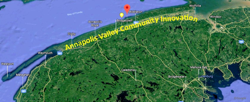 First, in last week’s Annapolis Spectator there was an interview with Bill Crossman about a project to install solar panels at the Centrelea Community Hall site. Second, at the latest Valley REN (Regional Economic Network) board meeting, Gerard D’Entremont was appointed Vice-Chair of the Board. In his introduction, Gerard described his position at (Nova Scotia Community College) NSCC Kingstec as the Community Innovation lead for the Annapolis Valley region. Intrigued, I requested a meeting this week with him at the Green Elephant in Kingston to learn more about this initiative.
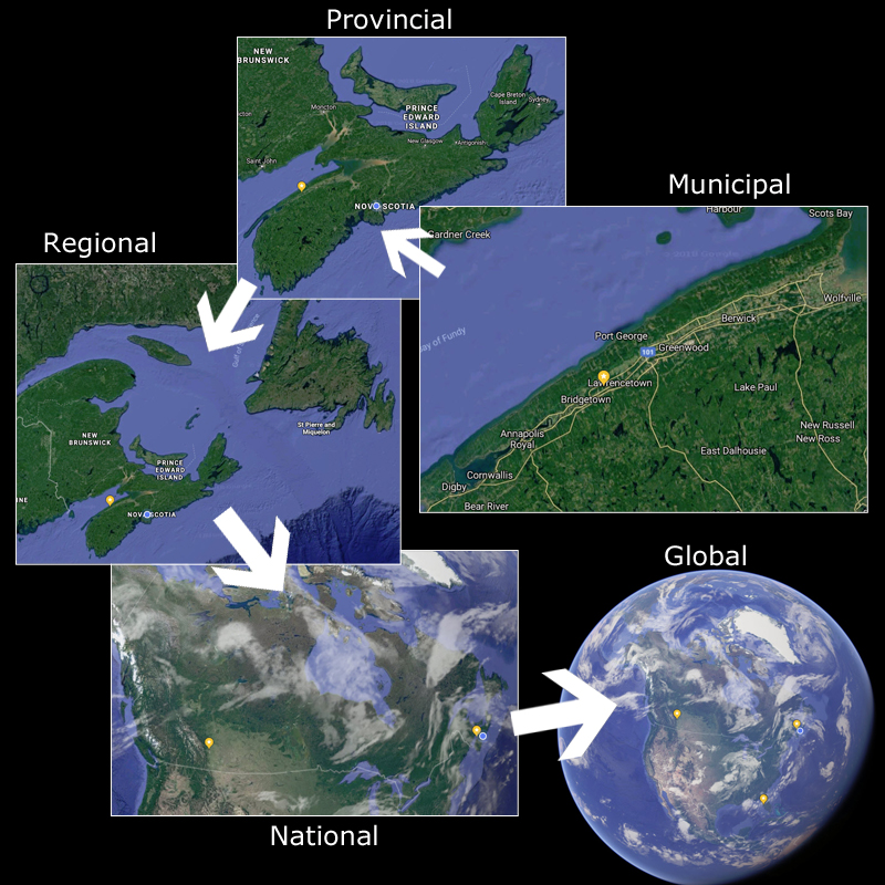 Stepping back, I recognized that, consciously or not, we are thinking at multiple scales. Within a geographic framework, this can mean:
 This blog was inspired by Arundhati Roy’s book Capitalism. A Ghost Story. It is a collection of short stories about life in India. Indeed, it is a VERY scary book [
 On the economic development front, The Centre for Local Prosperity is promoting
  I had noted that Chris Turner at BlueJack Consulting had developed a web GIS application for the Eastern Shore. Likely my best resource would be Eric Melanson at Esri Canada in Halifax. Eric was a COGS graduate from the ’80’s.
 At the end of my thread, I listened to a podcast by Geoffrey West. He had written a book, called Scale. In particular, West talks about scale in terms of large cities and companies. Of course, my interest was at the opposite end of the spectrum. What happens in rural Canada? These areas lack the diversity of our urban areas and thus are extremely vulnerable to the effects of change.
 And further:
 This quotation comes from a paper by Molly Ames Baker, found in a collection edited by Bob Henderson and Nils Vikander, Nature First: Outdoor Life the Friluftsliv Way.
 Baker also quotes from Barry Lopez, The Rediscovery of North America.
 Let us imagine we wanted to organize a team (or teams) of students to undertake the survey. Should the project be designed within a landfullness framework? Molly Ames Baker describes a framework for adventure-based programming: promoting reconnection to the land. Could the same philosophy be applied to the land use survey ?
 On the flight to Ottawa, I picked up a copy of the Nunatsiaq News (April 13 edition). There was an interesting opinion piece by Alex Buchan, Vice-President, NWT and Nunavut Chamber of Mines. He reviewed a book by Robert McPherson New Owners in their own land, Minerals and the Inuit Land Claim. “McPherson was a geologist hired by the Inuit Land Claim organization to identify mineral-rich lands that we would eventually select .”
 So, I checked his website
  While in Wolfville, I could not resist stopping at the second-hand bookstore. There, I found a book by Edmund Gilbert British Pioneers in Geography. This set of essays describes the Oxford School of Geography, going back to the twelfth century. A couple of quotations:
 The concept of a ‘community information utility’ (CIU) is very generic and subject to various interpretations. I suggest we add the descriptor ‘GEOGRAPHIC’ to avoid confusion with other utilities — like electricity, water, etc. — thus, CGIU.
 Around 2011, I was working at AGRG on Community Mapping. We had discovered the work of Paul Beach in Sault Ste Marie. He had developed the Community Information Utility (CIU) concept and implemented it in his region. The idea was to give citizens access to digital geographic information about their community. We brought Paul to Halifax and Lawrencetown. He met with Ian Thompson (Deputy Minister, and later with the Chronicle Herald). AGRG hired Ron L’Esperance’s company to see if the concept could work in Southwest Nova.