Posted in Event Review, Opinion

Transition: from North to South

Tuniq Times, the seasonal festival of dog sled, cross-country skiing, skijoring and skidoo races, started last week in Iqaluit. It was time to head South and see whether Spring had arrived in the Valley. It was hard to leave behind such wonderful snow for cross-country skiing.

nwOwnersInTheirOwnlandOn the flight to Ottawa, I picked up a copy of the Nunatsiaq News (April 13 edition). There was an interesting opinion piece by Alex Buchan, Vice-President, NWT and Nunavut Chamber of Mines. He reviewed a book by Robert McPherson New Owners in their own land, Minerals and the Inuit Land Claim. “McPherson was a geologist hired by the Inuit Land Claim organization to identify mineral-rich lands that we would eventually select .”

“Another important aspect of our land claim was to successfully negotiate the right to share with the government the resource development in all of Nunavut.”

” This was a very new and unique concept then, for the government to share resource management with us.”

” Co-management has given us a strong environmental protection system, to ensure that any development, not just mining, is done responsibly and in a way that Inuit knowledge is considered in ensuring that our land and waters and wildlife are protected.”

Back Home, it was time to catch up on events in the Valley. The best approach is to go to the Farmers Market in Wolfville on Saturday and to pick up a copy of the Grapevine. In the April 19-May 3 edition, two articles caught my attention.

I noted that Ed Symons, COGS faculty, is giving a talk at Acadia University on ‘Why Annapolis County is probably the most mapped county in the province”. The title of the article by Wendy Elliott MapAnnapolis could turn into MapValley ? (Wednesday 7 pm at the Irving Centre Auditorium).

The second article described a new exhibition of the work of Dick Groot at the Cedar Centre in Windsor (end of April – May 1018). This caught my attention for a number of reasons. Dick in a previous life, worked at ITC, Enschede in the Netherlands. When we were transforming NSLSI to COGS, we would often reference ITC as our European model.

ribbonToTheFutureSo, I checked his website eyeopener2013.com  and found the following quotation about the Ribbon to the Future project (a joint project by Dick Groot and Hannah  Minzloff).

” Ribbon to the Future. Ultimately, we intend to build an interactive website that allows the audience to add their own photography and stories thus creating a public information utility, ribbon to the future”.

Wow, Amazing! Does that not sound like the ‘community information utility?’

I contacted Dick, he explained that  ‘we set out to record photographically the old and the ‘anticipated’ new economy’.  The photo-based installation in Windsor is Closure: a photographer’s eye on an old economy.

Here is the challenge. What has replaced the old manufacturing economy? I also recall that part of the project was to focus on a linear narrative through the Valley. The ‘ribbons’ are the highways; Highway 1, Highway 201, and more recently Highway 101.

Time to go and see the exhibit. Time to think about the interactive website and its geography.

britishPioneersInGeographyWhile in Wolfville, I could not resist stopping at the second-hand bookstore. There, I found a book by Edmund Gilbert British Pioneers in Geography.  This set of essays describes the Oxford School of Geography, going back to the twelfth century. A couple of quotations:

From Carl Sauer, p.18

“a good knowledge of the work of one or more of our major personalities is about as important an induction into Geography as I am able to suggest”.

Or the author, on the decision in 1971 not to build a new London airport near Cublington, p.26 — ‘The defence of the natural beauty of the world’s landscapes is the inescapable duty of the geographer”.

References

Nunatsiaq News. Year 45 Number 3. April 13, 2018. Alex Buchan Required reading: new owners in our own land! Commentary. p.14.

The Grapevine. Issue No. 15.06 April 13 – May 3, 2018. Wendy Elliott. MapAnnapolis could turn into MapValley. p.11 and Mike Butler. Richard Groot’s Photo Finish. p.9.

Edmund W. Gilbert. 1972. British Pioneers in Geography. David & Charles, Newton Abbot, Devon.


Posted in New thinking, Opinion

A Community Geographic Information Utility Strategy

From the responses to my previous CIU blog, I offer some clarification and a strategic direction.

pickCGIUlayerThe concept of a ‘community information utility’ (CIU) is very generic and subject to various interpretations. I suggest we add the descriptor ‘GEOGRAPHIC’ to avoid confusion with other utilities — like electricity, water, etc. — thus, CGIU.

The key is to provide our community access to the best available information about our geography — our land, people and social infrastructure.

To go forward, I propose three steps.

STEP ONE
Re-visit the implementation and status of what has happened over the last ten years with CIU in Sault Ste. Marie, and investigate other examples elsewhere (or similar concepts).

STEP TWO
Explore non-profits and other delivery options for a CGIU in our region including, for example, Annapolis Valley Regional Library, NS Community College, and the Valley Regional Enterprise Network. What is important is strong citizen involvement.

STEP THREE
Re-visit the CLICK Project (this was a geographic information project funded under the SMART communities fund) to elicit lessons learned.

In summary, what is happening elsewhere, what potential organizations exist locally that could handle CGIU, and how can we avoid previous mistakes in the region?
It is apparent to me that the same CGIU ingredients exist as they did  ten years ago, but fundamental technologies have advanced:  access to high-speed Internet; better GIS tools for the public; a ubiquitous social network; and, a recognition of the need to empower citizens in rural areas with high-quality geographic information for more informed, decision making.

I look forward to your comments and improvements.

Posted in New thinking, Opinion

Community Information Utility: it’s time has come.

tablet-431647_960_720Around 2011, I was working at AGRG on Community Mapping. We had discovered the work of Paul Beach in Sault Ste Marie. He had developed the Community Information Utility (CIU) concept and implemented it in his region. The idea was to give citizens access to digital geographic information about their community. We brought Paul to Halifax and Lawrencetown. He met with Ian Thompson (Deputy Minister, and later with the Chronicle Herald). AGRG hired Ron L’Esperance’s company to see if the concept could work in Southwest Nova.

Roll forward to 2018.  From Larry Powell’s recent article in the Annapolis Spectator on sustainable forestry, we see that Annapolis County is expressing an interest in “evidence-based management”.

If they are to be accountable, then we must agree on the underlying information. In my mind, it’s positive to see the municipal government voice these concerns to the province and the Lahey Commission. However, it does not address my question, as a citizen, about access to geographic information. Not only access but who manages the technology. Both the provincial and the municipal government are supposed to be representing the interests of their constituency, i.e. citizens, and that includes access to information.

For example, with the MapAnnapolis project with heritage mapping of Centrelea, Round Hill and Granville Ferry who manages the information? How is it accessible to citizens?

Besides the forestry example, there is the question of arsenic and uranium in the groundwater of South Mountain. Who manages that information? How does it impact the health of citizens or impact property values?

If we roll back, even further, 1987, COGS  hosted a one week CCA Summer Institute on GIS. We brought together a number of the leading thinkers on GIS technology and provided a hands-on education for the next generation of university professors.

Next month,  the Canadian Cartographic Association (CCA) will be holding its Annual conference for the first time at COGS. Again, we will be bringing together some of the same thinkers, thirty years later.

For example, Professor Michael Goodchild in 1987 was at the University of Western Ontario. Shortly, thereafter he moved to the University of California, SantaBarbara as part of the National Center for Geographic Information and Analysis. At UCSB, he developed the Alexandria project. This project placed GIS and Remote Sensing technology in the Library. Subsequently, James Boxall championed a similar concept of a Map Library at Dalhousie University. Goodchild is one of the keynote speakers at the CCA meeting. His talk is entitled ‘Place, Space and GIS’.

Let’s join the dots. What would it take to have a community information utility available to citizens, perhaps initially as a pilot in Annapolis County,  through the Annapolis Valley Regional Library or the NSCC at COGS?

We already have the example of the legacy of Walter Morrison’s work as a Map Collector and Cartographer at COGS. We have access to the results of Walter’s life work.

Why not put a public face on this geographic information? We have made some progress in our public history, but we have a long way to go in our public geography. If we had a Community Information Utility, there would be an accessible repository for the results of citizen science that would complement our local efforts in, for example, Clean Annapolis River project, MapAnnapolis and Southwest Nova Biosphere Reserve Association.

Reference Links
The Alexandria project
Community Information Utility
MapAnnapolis
CCA conference

Footnote
The CCA conference is May 30- June 1. It includes presentations on First Nations mapping, the UNESCO Grand Pré site, community mapping, keynotes on trends in cartographic technology and thinking.

Posted in Event Review, Nature

Northern Musings

Everyone returned safely from the four-day dog sledding trip. dogSledCrew
The GARMIN InReach technology worked well, allowing us to track the progress from cabin to cabin. With Edward’s help, I was able to follow their route across the sea ice from Iqaluit and back.screenshot_08_06Apr18 2-21-13 PM
Indirect exposure to this type travel in Winter raised a number of questions or musings.
In Northern latitudes, there is the opportunity to experience the same landscape in very different conditions. In the winter, travel across the sea ice is either by dog team or skimobile. In the Summer, Frobisher Bay is accessible by boat. On the land, the lakes are frozen — a beautiful blue ice, again Winter travel uses the same transportation or skis. Hillsides are rounded out by extensive snow banks. In the summer, it is hiking or canoe.
If this landscape changes so dramatically with the seasons, how does this increased knowledge of the same space, impact our relationship to the land?
There are stories about the land, for all seasons. How will climate change impact the landscape, our travel and hence the narrative?
Meanwhile, back in Iqaluit, I am tucked away, reading some books from England. The current tome is Nicholas Crane’s ‘The Making of the British Landscape‘. Over five hundred pages, describing the changes in Britain from 10,000 BC to the present day. In the frontispiece, Crane comments:
     ‘To care about a place, you must know it’s story’.
In the Inuit oral tradition, these stories extend across the landscape in ALL seasons. Each season offers its own unique version of the landscape.
REFERENCE
Nicholas Crane. 20816. The Making Of the British Landscape. W & N , London.
FOOTNOTE

Nicholas Crane is an author, geographer, cartographic expert. He has presented several acclaimed series on BBC2, among them Map Man, Great British Journeys, Britannia, Town and Coast.  He was elected President of the Royal Geographical Society in 2015.
Posted in Book Review, New thinking

Up Here: the Voice of Canada’s Far North

As I fly from Ottawa to Iqaluit, I notice my free copy of “Up Here” magazine in the seat pocket in front of me. After a few days, hanging out indoors, waiting for a blizzard to die down, I start to read back issues of the magazine. upHareMagCover_Aug2015The August 2015 issue had an article by Tim Edwards (p 42-50) entitled ‘From the West to the Wilderness‘.

“Europeans arrived in North America looking for wealth and the Pole. Explorers defied death for glory. What drives today’s adventurers ?”

The article begins with the Franklin Expedition, and then talks about Frederick Cook and Robert Peary “who were welcomed as kings by governors and the public alike, as they stopped In various ports on their way home from the North Pole.”

“Now the world is mapped and the heroes of old are long in their graves. When people go missing in the High Arctic, we consult SPOT trackers, we send out search and rescue missions that last days, not years.”

“Sarah McNair-Landry and Erik Boomer and their dog team spent 120 days circumnavigating Baffin Island. Their goal was to retrace a journey by McNair-Landry’s parents took twenty-five years earlier.”

“Gear and communications are leagues above what it used to be. When Franklin’s ships were lost, other ships were commissioned to follow the route and find the crew – who were stuck in some unknowable corner of the Arctic Archipelago – at their own peril.
Today adventurers have SPOT and InReach devices, satellite phones and helicopters can extricate them from tight spots.”

Today, 2018, with new underwater technology, the wrecks of the Erebus and Terror have been found. Many books have been written on Arctic exploration and its historical context, whether from the European or American point of view. A new history is being written by modern-day adventurers, combining traditional transportation and knowledge, with modern technology, and from a variety of disciplines.

“Whereas early explorers brought European society to the Americas and 20th-century explorers were out to leave a  legacy and gain high esteem. Today’s explorers are mostly unknown outside adventure travel circles, looking for not much more than to leave society and experience the world in its natural state.”

REFERENCES
Up Here. The Voice of Canada’s Far North. Published by Canada North Airlines.

Specific back Issue. August 2015. Article by Tim Edwards. From the West to the Wilderness. p. 42-50.
Check Canadian North web site for upnorth.ca

For US perspective,
Michael F. Robinson. 2006. The Coldest Crucible. Arctic Exploration and American Culture. University of Chicago Press.

There are many books written about the European perspective on Arctic exploration and the prevailing European culture.

FOOTNOTE
blog_01a
Today, my son headed out for a four-day trip via dogsled team, across sea ice and through a blizzard. Garmin technology allowed him to track and relay his position, average speed, distance traveled, maximum elevation, and time, and send-receive text messages. As I was unable to access these via my computer, I worked with Edward in Nova Scotia to relay that information back to me.
As noted by the Up Here magazine writer, Tim Edwards, “Gear and communications are leagues above what it used to be.

Posted in Book Review

Uqalurait: An Oral History of Nunavut

bookCover_iqalurait
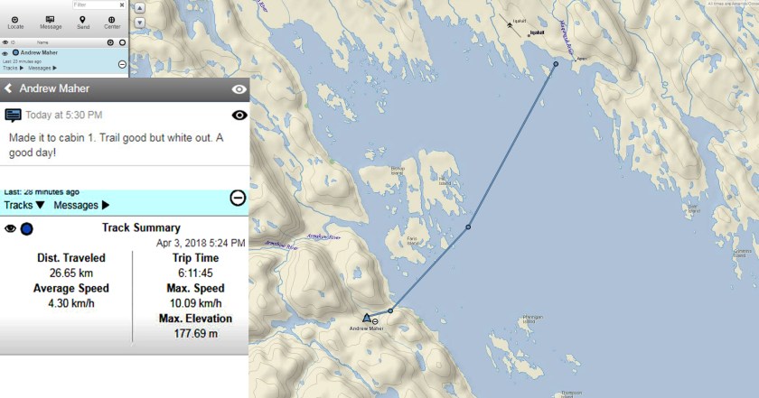
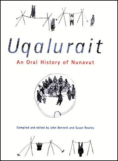
” During a blizzard, the snowfall is usually soft. A type of snow mound, uluangnaq, is formed. The (prevailing wind)  then erodes the mound, thereby forming an uqaluruq – a drift with a tip that resembles a tongue (uqaq) – this is pointed and elevated from the ground – Uqalurait  are formed by the uangnaq , (west- northwest wind)” p xxv

Abraham Ulayuruluk, Amitturmiut

“In Winter we used Uqalurait to tell us which direction to go. We would follow the direction of the Uqalurait.” p. xxv

Uqalurait
Mariano Aupilarjuk, Aivilingmiut

“In the past, Inuit history was transmitted orally from generation to generation. The Inuit who shaped this project decided that, unlike other Arctic histories, this one should concentrate on the time before extensive contact with the Europeans.” p. xxvii

” The Steering Committee wanted this work to get to the heart of Inuit culture and give the reader a sense of the richness and completeness of life that countless generations lived on the land and the sea ice.” p. xxvii

“Most of the quotations represent life as Inuit lived it from the end of the nineteenth century into the early twentieth century.” p. xxvii

The book is divided into two parts: Inuit Identity and Regional Identity. Within these two parts, the emphasis is upon five themes: flexibility, sacrifice, social control, sharing and respect.

One final quotation, under Section 12. The Land.

” The living person and the land are actually tied together because without one the other does not survive and vice versa. You have to protect the land in order to receive from the land. If you start mistreating the land, it won’t support you …
In order to survive from the land, you have to protect it. The land is so important for us to survive and live on; that’s why we treat it as part of ourselves,” p. 118.

Mariano Aupilaarjuk, Aivilingmiut.

Reference

John Bennett and Susan Rowley (compiled and edited) 2004. Uqalurait. An Oral History of Nunavut. McGill Queens University Press.

Posted in Uncategorized

Stories and Maps: the Franklin expedition

On the way to Iqaluit, we had a stopover in Ottawa. On the recommendation of Andrew, my son, we went to see the Franklin exhibition at the Canadian Museum of History.
franklinExpedition

There were many aspects of the exhibit design which caught my imagination. At the entrance, a projector system showed the history of exploration routes into the Arctic. Each route revealed more of the known geography of the North. These images served to provide a graphic context for the Franklin expedition. The layout of the ship on the floor of the gallery again provided a tremendous sense of the size and plan of the individual vessel. Third, and most revealing to myself, was the combination of Inuit storytelling with current artwork.

While listening to the recordings, it became clear that the role of storytelling in the oral Inuit culture was critical to our understanding of the fate of the Franklin expedition. These stories of the landscape provided a narrative which allowed the Inuit to travel from place to place. The stories were retold in the igloos by the elders. They replaced maps, although there were wooden maps carved to identify islands and inlets.

Once we arrived in Iqaluit, I had access to books. I found Woodman’s book Unravelling the Franklin Mystery: Inuit Testimony. This gives more background to the many insights at the exhibition. A second book, on Andrew’s bookshelf, was Annie Dillard’s Teaching a Stone to TalkExpeditions and Encounters. It includes An Expedition to the Pole p 29-64. This essay is brilliant, divided into several headings: The Land, The People, The Technology. These topics and their focus on the Franklin Expedition reverberates with the exhibition (written in 1982).

Meanwhile, as I was flying from Ottawa to Iqaluit, I was re-reading Robert MacFarlane, The Wild Places p 17.

“I also decided that, as I traveled, I would draw up a map to set against the road atlas. A prose map that would seek to make sense of the remaining wild places of the archipelago visible again, or that would record them before they vanished for good. This would be a map, I hoped, that would not connect up cities, towns, hotels and airports. Instead, it would link headlands, cliffs, beaches, mountain tops, tors, forests, river-mouths and waterfalls.”

One last story. Talking to Julia last night, I found that she had been hired to teach Map Making at Nunavut Arctic College. On the side table, I found, Map Use: Reading, Analysis, Interpretation by Kimmerling et al. Six hundred and fifty pages. With a Foreword by Jack Dangermond at Esri.

It seems that we have come ‘full circle’.

References

David C. Woodman. 2015. Unravelling the Franklin Mystery: Inuit Testimony. Second Edition

Annie Dillard. 1982. Teaching a Stone to Talk: Expeditions and Encounters.

Robert MacFarlane. 2007. The Wild Places. Penguin Books.

Jon Kimerling et al. 2016. Map Use: Reading, Analysis, Interpretation.

Elaine Anselin. Closing in on Franklin. Up Here. Jan/Feb 2018. p 55-62


Posted in New thinking

The Nunavut Landscape: maps and dreams

Every Spring, Heather and I head North to help with grandchildren. Andrew takes off on multi-day dog sledding trips and often Julia has to lead school trips to the South. This year, since the end of February, I have spent time in England, Nova Scotia and soon, Nunavut. This blog completes a trilogy on the landscape: the Royal Landscape of England with its emphasis on commodity and property; the Nova Scotia landscape with the emphasis on the harvesting on Crown land; and now the landscape of Baffin Island.

In the latest Guardian Weekly, Katharine Norbury reviewed a new book by Tim Dee, Ground Work: a collection of writing on places and people.

groundwork

One of the essays is by Hugh Brody. In the words of the reviewer:

“Hugh Brody in meditation on the idea of home recounts his experiences of mapping the northern Baffin region of the Canadian Arctic to show all the places in which Inuit have hunted for seal, walrus, narwhal, caribou, hare and polar bear. He records the places where they gathered blueberries, cranberries and the eggs of Arctic terns. And to what purpose ?”

“To develop a legal basis by which the Inuit people might lay claim to the land that has sustained them  for millennia.”

As Norbury concludes, ” one does not need to be a farmer, or a conservationist to justify a relationship with the wild. We just need to learn to look properly, and to find the common ground”.

Imagine if Hugh Brody and others had conducted similar studies with the Mi’kmaq in Nova Scotia. Would there be a different attitude towards the land? Heather Stewart had the idea that we take the work of Dave and Paulette Whitman and map the history described in their first chapter, The Mi’kmaq of Paradise and Area. Or we could research the name, Eel Weir Lake; or talk to Roger Lewis at the Nova Scotia Museum about the location, construction and importance of eel weirs to the nomadic culture. Another resource would be the book by Trudy Sable and Bernie Francis The Language of this Land, Mi’kma’ki.

From our time in Haida Gwaii, we know that the Haida culture was instrumental in stopping the logging of old growth forest on the island and along the coast of Northern British Columbia.

This week, reading Lesley Choyce Seven Ravens, I was reminded of the importance of raven to the Haida. Choyce tells the story of walking from the south shore inland until he has seen seven ravens. He then ends his journey and turns back for home.

mapsAndDreams

Maps and Dreams is the title of Brody’s classic book. We can still dream about other cultures and the way they understand the landscape. We can still think about maps which help us find our way through the wilderness.

Now I am ready to see the changes in Iqaluit: to the landscape, the buildings and the people.

Thanks to the Road to Georgetown team. Heather Stewart for sharing in many of the ideas and experiences; likewise Edward Wedler for his creative input.

References
Tim Dee. 2018.  Ground Work: writings on places and people. Jonathan Cape.

Katharine Norbury. 2018. Wonder all around us. The Guardian Weekly 09.03.18. p. 36

Dave and Paulette Whitman 2016. The Valley Chronicles. Tales of the Annapolis Valley. Bailey Chase Books.Paradise.

Trudy Sable and Bernie Francis. 2012. The Language of this Land, Mi’kma’ki. CBU Press.

Lesley Choyce. 2009. Seven Ravens Two summers in a life by the sea. Wolsak and Wynn.

Hugh Brody 1992. Maps and Dreams. Douglas and McIntyre.

Roger Lewis is  Curator of Ethnology at Nova Scotia Museum


Posted in New thinking

The Nova Scotia Landscape: returning to forest cutting

Two months ago (January 18th), I wrote a blog about the cutting of Crown Land on South Mountain in the Inglisville area. As the result of some recent questions, it was time to revisit the Rifle Range road to Eel Weir Lake. With minus ten degrees centigrade and some fresh snow overnight, it was a perfect day for cross-country skiing.

There has been significant new cutting closer to the rifle range. Indeed part of the property, designated as a buffer to the rifle range, has been harvested. The stacks of both hardwood and softwood are higher and longer.


From the perspective of citizen science, a logical next step would be to contact Neil Green again and see if we could conduct another drone flight over the site (see earlier blog video).

After that previous blog, I contacted David Colville at COGS. He identified two relevant websites to explore. The first was the provincial Harvest Plans Map Viewer which shows the locations of the cuts. The second was the Global Forest Watch site at the University of Maryland which shows the history of forest change from satellite data since 2000.  Both of these sites are relevant in terms of a fact base for decision making.

Let’s sidestep for a moment. My second update relates to my recent visit to England. While there, I was referred to the writing of George Monbiot. On returning home, I received a new subscription to the Guardian Weekly. Lo and behold, on the back page of the March 2-8th edition, Monbiot has a column on the town of Frome in Somerset. It is entitled:

“One UK town has discovered a potent cure for illness – community. Frome’s dramatic fall in emergency admissions to hospitals should be a lesson for all of us”.

Or take his final paragraph:

” In other words, the evidence strongly suggests that social contact should be a prescription, as it is in Frome. But the silo effect, budget cuts and an atmosphere of fear and retrenchment ensure that precious little has been done.”

Sound familiar!

Let us join the dots. Healthy community engagement is a positive force in rural parts of England and Canada. We can learn from each other. Citizens can help make sure that decisions about the health of our landscape and the health of citizens are based on verifiable facts, rather than political expediency.

Let’s give the final word to Sharon Butala:

See her article in The Walrus.

“Against Ageism. It’s time to stop treating senior citizens as a burden”.

Or in the words of Rachel Carson:

“The real wealth of the Nation lies in the resources of the earth – soil, water, forests, minerals and wildlife. The administration is not properly, and cannot be, a matter of politics.”


References

George Monboit. One UK town has discovered a potent cure for illness – community. Frome’s dramatic fall in emergency admissions to hospitals should be a lesson for all of us. The Guardian Weekly. 2-8th March 2018

Sharon Butala. Against Ageism. It’s time to stop treating senior citizens as a burden. The Walrus Vol.15 Number 3 April 2018. p 15-19.

Thanks again to Heather Stewart for the photographs and support, and Edward Wedler for the graphics manipulation. I take full responsibility for the words.


Posted in Book Review, Nature

The Royal Landscape: visiting Middle England

For the last two weeks, I have been visiting friends and family in England. Specifically, I stayed in Byfleet, Surrey.

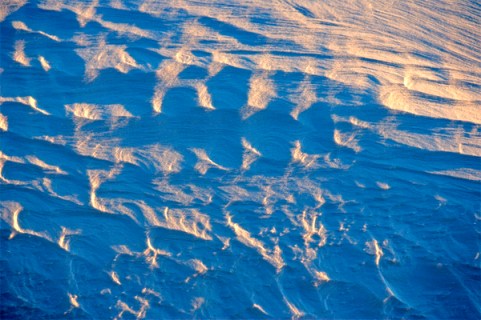
My original intent was to meet my brother for a nostalgic walk throughout our childhood neighbourhood: Twickenham, Whitton, Hounslow, and Hampton. This was abandoned when a winter storm hit England and Europe (the Beast from the East) and he was unable to join me.

But, lets start from the beginning. I left Halifax for Heathrow airport reading Richard Holmes This Long Pursuit. By the time I had landed, the book was finished. I was up to date on the confessions of a Romantic Biographer. Filled with essays on the lives of Keats, Shelley, Byron, Coleridge and Blake.

First stop was the Royal Horticultural Society (RHS) gardens at Wisley. The large greenhouse had its annual display of tropical butterflies. On entering the gardens, I noted that the RHS Library had a book sale. This led two purchases. At the end of the visit, we ended up at the shop. There is a section of the store dedicated to gardening and the English landscape. With future walks in mind, I walked away with seven additional purchases (see references below).

As I pondered on my childhood days in England, I recalled listening to BBC Radio 4. When I found Caroline Hodgson For the Love of Radio 4, there were two quotations that struck a chord.

‘Robin Oakley relates that Jeffrey Archer once said to him that the world is divided into those who know how to make money and those who don’t. You, Robin, are in the second category !’ I guess that Bob Maher is in the second category too. p.89

(Jeffrey Archer is a British ex politician and story teller)

Talking about the program, Letter from America by Alistair Cooke:

‘It is perhaps the ultimate audio blog, and like all good bloggers Cooke knew that his words were intended for an audience rather than the product of a mere navel-gazing exercise’ p 232

This left me thinking, well  who is my audience ?

I found a partial answer when I was reading The Spectator. Hugh Thomson reviewed two books under the title ‘A Drizzle of Nature Writers’. He reviewed books by Tim Dee and Paul Readman (see references). Readman references George Orwell (ah-ha):

‘the world centres around the English village, and round the trees and hedges of that village, rather than the houses and the people’.

Readman concludes his book:

‘ we still like to define ourselves as an essentially rural nation, despite all indications to the contrary’

or from Orwell:

‘There is no question that a love of what is loosely called Nature is widespread in England’

Leaving Thomson to state:

‘The fact is that those who really have to deal with Nature have no cause to be in love with it’.

These literary digressions have to be put in the context of my time in England. Most days there was the opportunity to walk through the Surrey landscape. This included Windsor Great Park, Richmond Park, the River Wey Navigations. One trigger for me, was the branding of The Royal Landscape. To park your car and go for a walk through Savill Gardens or the Heather Gardens, you could purchase a membership  card to The Royal Landscape. Likewise, if you were a polo player, you could do the same.

This raised the question of land ownership in Surrey. There are numerous estates, clubs, golf courses in this part of England. How does this contrast with rural England or rural Nova Scotia? My tentative conclusion is that they are totally different worlds, with very different sets of values.

My take home message, besides the books, is to research in more detail the writing of George Orwell, and then to move to the present day and look at current writers on ‘the houses and the people’.

One final story. At Waterstones, I noticed a small book (an essay) by Robert MacFarlane, The Gifts of Reading. The essay is only thirty four pages long. I purchased five copies to give away as gifts. From p 19, where MacFarlane references The Gift by Lewis Hyde.

“Gifts give on”, says Hyde, this is their logic. They are generous acts that incite generosity. He contrast two kinds of ‘property’: the commodity and the gift. The commodity is acquired, and then hoarded, or resold. But the gift is kept moving, given onwards in a new form. Whereas the commodity circulates according to the market economy, the gift circulates according to the gift economy. In the market economy, value accrues to the individual by means of hoarding or ‘saving’. In the gift economy value accrues between individuals by means of giving and receiving’.

What exactly has happened through the branding of The Royal Landscape? Is it a commodity? What is meant by the term ‘Middle England’? Is that the new ‘middle class’ in England?

References

Richard Holmes.2016 This Long Pursuit. Harper Collins, London.

Caroline Hodgson. 2014. For the Love of Radio 4. An Unofficial Companion. Summersdale Publishers Ltd.

At RHS Booksale

Peter Alfred Please. 1997. Holine – A British Journey Bulletins from the Wayside 1950-1997. Away Publications

Michael Leapman. 2000. The Ingenious Mr. Fairchild. The Forgotten Father of the Flower Garden. Headline Books.

At the RHS book store.

Rob Cowen. 2015. Common Ground.Windmill Books.

Nicholas Crane. 2007. Great British Journeys. Weidenfeld and Nicholson.

Nicholas Crane. 2016. The Making of the British Landscape.From the Ice Age to the Present. Weidenfeld and Nicholson.

Matthew Engel. 2014. Engel’s England. Thirty nine Counties, One Capital and One Man. Profile Books.

Kathleen Jamie. 2012. Sightlines. Sort Of books

Nan Shepard.2011. The Living Mountain. Canongate Books

Christoper Somerville. 2017. The January Man. A Year of Walking Britain. Black Swan.

Hugh Thomson. A Drizzle of Nature Writers. The Spectator. March 3, 2018. p 48.

He reviews books by Tim Dee and Paul Readman.

Tim Dee (ed). Ground Work: Writings of People and Places.

Paul Readman. Storied Ground: landscape and the shaping of National Identity.

Robert MacFarlane. 2016. The Gifts of Reading. Penguin Books. 34pp.

Thanks as always to Edward Wedler for his graphics capabilities.