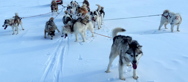
 For the last few years, every Summer, we have provided a holiday camp for two retired Inuit sled dogs: Uke and Siq Siq. They were part of a litter born in Pond Inlet, Nunavut about twelve years ago, under the watchful eye of my son, Andrew. Later, they went to Prince George, where they provided Patrick, my eldest son, with the pulling power for ski-joring. They arrive in Paradise, in May and usually return home by early September.
While they are in our care, we get used to their howling at night with the local coyotes, living on the floodplain along the Annapolis River. Or they howl in response to the sirens from emergency response vehicles.
Yesterday, they returned to their permanent home. This year it is to Petawawa in the Ottawa Valley. Today, it feels very strange to pass by their pen, and not to receive a welcome or reaction.
We have now entered apple harvesting season. 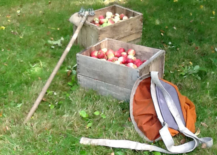 In the Valley, a late frost in early June impacted many of the apple growers in the region. Fortunately, for us, Raymond Hunter planted his trees in a tree protected area. This has allowed us to ship the early drops to Brian Boates in Woodville. Now we have started picking directly from the trees. The first cycle will be the Nova Mac variety, to be followed later, by the Mac Free. All of these organic apples will be juiced at Boates cider mill and then transported to Ironworks Distillery, Lunenburg as a key ingredient in their apple brandy. If we have a spell without too much rain, we should be able to pick a couple of bins per day. (note: one bin can hold between 18-20 bushel boxes).
For most Nova Scotians, September is ‘return to school’. That no longer applies for Heather and myself. Instead, it is a time when we miss the sound and companionship of the retired sled dogs. It is also a time of physical labour, as we climb the apple ladders, fill the bushel boxes and then load into the larger bins. The tractor, with its forklift, comes out of the barn to load the bins onto a flat-bed truck for transportation.
Other signs of change found in the media include comments on the Lahey report. In particular, I recommend Raymond Plourde, Ecology Action Centre. He has an online opinion piece in the Chronicle Herald, September 8th Lahey Forestry report; the good, the bad and the missing.
Or take a look at the poster produced by the Valley REN for the Devour Festival, this October. It promotes the unique qualities of living and working in the Annapolis Valley.
Acknowledgements
I want to acknowledge my monthly conversations at the End of the Line pub with Frank Fox and Paul Colville. They encourage me to keep writing my blog. Thanks, as usual, to Edward for his graphics, and to Heather for sharing the workload.
References
Raymond Plourde. Chronicle Herald September 8, 2018. Opinions. Lahey Forestry report: the good, the bad and the missing.
Deborah Dennis. Valley REN. Forwarded a new poster for the Devour Festival. September 11,2018.
 In the latest issue of Saltscapes, two articles caught my attention. Jodi DeLong reviewed Sandra Phinney’s book ‘Waking up in my own backyard. Explorations in Southwest Nova Scotia. Or as DeLong titled her article ‘ Celebrating our own spaces’
 There, I discovered:
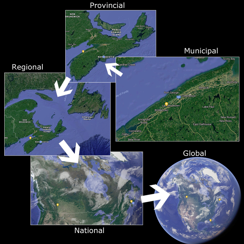 Stepping back, I recognized that, consciously or not, we are thinking at multiple scales. Within a geographic framework, this can mean:
 At the end of last week, we decided to take a trip along the Parrsboro shore, primarily to check out the Fundy Geological Museum. On our way home, we stopped at
  At the church, I picked up a copy of the brochure Elizabeth Bishop’s Paris. This small brochure describes two visits to Paris in the mid-1930’s. Interestingly, it includes a map of central Paris, identifying locations visited by Bishop and Louise Crane. The map also shows the location of the first conference on Elizabeth Bishop in France. Elizabeth Bishop in Paris: Spaces of Translation and Translations of Space. 6-8 June 2018. The text was written by Jonathan Ellis, Sheffield University.
 This blog was inspired by Arundhati Roy’s book Capitalism. A Ghost Story. It is a collection of short stories about life in India. Indeed, it is a VERY scary book [
 On the economic development front, The Centre for Local Prosperity is promoting
  I had noted that Chris Turner at BlueJack Consulting had developed a web GIS application for the Eastern Shore. Likely my best resource would be Eric Melanson at Esri Canada in Halifax. Eric was a COGS graduate from the ’80’s.
 At the end of my thread, I listened to a podcast by Geoffrey West. He had written a book, called Scale. In particular, West talks about scale in terms of large cities and companies. Of course, my interest was at the opposite end of the spectrum. What happens in rural Canada? These areas lack the diversity of our urban areas and thus are extremely vulnerable to the effects of change.
 And further:
 My interest was two-fold. I wanted to challenge myself and find out what would be the process if I decided to return to work ( I retired in 2011). Secondly, I wanted to understand the nature of the employment hub in Middleton
  Another connection, that appeared in my email box that day, was from
 In our working world, we become used to responding to a variety of tasks and deadlines. What happens in our retirement? We are still geared to tasks and specific timelines. Imagine a situation where two individuals who have structured their lives according to tasks, and deadlines. Suddenly, in retirement, we need to change our behaviour and recognize that living in a rural society, the timelines are driven more by natural cycles. The green beans and the gooseberries need to be picked. The beans have to be blanched, before freezing. The gooseberries turned into jam.
 In the teaching environment, we understand semesters, final examinations, Summer vacation. In the research environment, there is fieldwork, analysis, writing reports and going to conferences. There is also the structure of the research grant: proposals, the research and the deliverables.
 Along with retirement comes the role of ‘elder’. What have we learned from our career? Can we mentor the next generation to address environmental issues? Or the relationship between ‘Man and Nature’? What processes exist so that this knowledge can be applied to current issues in society? How can we change our educational institutions? How can we change our governing institutions?
 It was forwarded to me by Gregory Heming, Chair, Forestry Advisory Committee. It is a summary of their initial research and makes a set of recommendations to council. The primary recommendation is to adopt the ‘Climate Forest’ paradigm.
